undefined
Apparel & Fashion
Loading subcategories...
View More

Description
Professional plane table surveying services utilize traditional field mapping techniques to deliver accurate graphical representations of land features and spatial relationships. T...
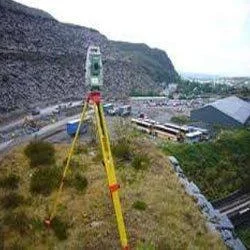
Professional plane table surveying services utilize traditional field mapping techniques to deliver accurate graphical representations of land features and spatial relationships. This method employs a drawing board mounted on a sturdy tripod combined with an alidade for direct sighting and plotting onto paper in the field. The immediate visual output enables real-time verification and adjustments during the survey process, ensuring high accuracy while eliminating the need for complex electronic equipment. This approach is particularly valuable for projects requiring quick turnaround times and for working in challenging environments where modern surveying equipment might face operational limitations.

Multiple industries depend on plane table surveying for their critical mapping and planning requirements. Civil engineering firms utilize these services for road alignment projects, irrigation system planning, and preliminary construction site assessments. Mining companies employ plane table surveys for mapping exploration areas, monitoring extraction progress, and planning access routes in remote locations. Urban development projects benefit from this method for land subdivision planning and infrastructure development, while environmental consultants use it for habitat mapping and watershed analysis. The construction industry values this technique for site verification, foundation planning, and monitoring earthwork quantities throughout project execution phases.

Our plane table survey services deliver exceptional business value through reliability, cost-effectiveness, and practical accuracy that meets professional standards. Unlike electronic methods requiring specialized operators and sophisticated software, plane table surveying provides immediate, understandable results accessible to all project stakeholders. The equipment demonstrates robust performance with minimal maintenance requirements, functioning reliably across various environmental conditions. This method eliminates risks associated with data corruption or software compatibility issues common in digital surveying techniques, while the simultaneous surveying and mapping process reduces project timelines and facilitates quicker decision-making for clients.

Key Features:
- Direct field plotting eliminates office processing time and transcription errors
- Traditional methodology proven reliable across diverse environmental conditions
- International quality standards compliance ensuring survey accuracy
- Robust equipment performing effectively in remote and challenging locations
- Immediate visual verification enabling on-site quality control and adjustments

Benefits:
- Reduced project timelines through simultaneous surveying and mapping processes
- Cost-effective solution requiring minimal equipment investment and maintenance
- Enhanced decision-making with immediate, understandable visual results
- Reliable performance in locations where electronic equipment may fail
- Elimination of software compatibility issues and data corruption risks
Specifications
| Additional Information | |
|---|---|
| Country of Origin | India |
| Customisable | No |
Application
Plane table surveying provides rapid field mapping with immediate graphical representation of terrain, eliminating complex calculations and enabling real-time verification directly on site. This method is particularly effective in remote locations where electronic equipment may be impractical or unreliable, ensuring consistent performance regardless of environmental challenges.

Our services deliver detailed base maps, contour mapping, and preliminary site investigations with exceptional flexibility for projects of various scales. The visual nature of this technique allows for immediate error detection and field adjustments without office returns, providing clients with accurate spatial data that supports informed decision-making throughout project development phases.
- Land development projects requiring quick topographic surveys for initial planning
- Construction site verification and layout planning for infrastructure development
- Mining operations for mapping exploration areas and monitoring extraction progress
- Agricultural land planning including irrigation system design and terrain analysis
- Environmental and archaeological site documentation with precise spatial recording
Trade Details
| Available Stock | In stock |
| Sample Availability | No |
Payment Terms
| Payment Terms |
|
Company Profile
Eagle Engineers, Pune, Maharashtra
 Maharashtra, India
Services & Support
Factory Details
Factory SizeBelow 1000 sqm
Annual Production Capacity0
Main Markets
North America
South America
Eastern Europe
Southeast Asia
Central America
Professional Plane Table Surveying Services For Accurate Land Mapping
Professional plane table surveying services deliver accurate land mapping and site planning for construction, mining, and civil engineering projects, ensuring reliable and precise field surveys with immediate results.
Min. Order Quantity: 1 units
Shipping
Shipping fee and delivery date to be negotiated. Contact supplier now for more details.
Eagle Engineers, Pune Maharashtra, India
Services & Support