undefined
Apparel & Fashion
Loading subcategories...
View More
Description
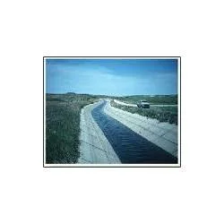
We deliver comprehensive canal survey services throughout Maharashtra, specializing in water infrastructure development and management solutions. Our experienced surveying team emp...
We deliver comprehensive canal survey services throughout Maharashtra, specializing in water infrastructure development and management solutions. Our experienced surveying team employs advanced technology including high-precision GPS systems, total stations, and aerial drone mapping to provide accurate data for canal projects of all scales. We manage complete survey processes from initial feasibility studies to final as-built documentation, ensuring precise measurements for alignment planning, cross-section analysis, and volume calculations. Our services form the foundation for effective water distribution systems that support agricultural productivity, municipal water supply, and industrial requirements across the region.

Our canal survey expertise serves multiple sectors including agricultural irrigation departments, water resource management authorities, civil engineering consultancies, and infrastructure development organizations. We collaborate with government irrigation initiatives, private agricultural developers, and municipal water boards requiring precise canal data for project planning and execution. Our surveys support various project phases including new canal construction, existing system modernization, maintenance strategy development, and water efficiency enhancement programs. We possess deep understanding of Maharashtra's varied topography and specific water management challenges.

We deliver significant business value through reliable, accurate surveys that prevent costly construction errors and ensure optimal water flow efficiency throughout canal networks. Our extensive experience with Maharashtra's canal systems enables us to provide insights that extend beyond basic measurements, offering practical implementation recommendations based on local conditions. Our commitment to quality assurance ensures every survey meets engineering standards and regulatory compliance requirements, providing clients with confidence in their infrastructure investment decisions and project outcomes.

Key Features:
- Advanced GPS and drone technology for precise geospatial measurements
- Comprehensive topographic and alignment survey capabilities
- Experienced surveying team with extensive Maharashtra regional knowledge
- Complete survey packages tailored to specific project requirements
- Detailed engineering reports with certified data accuracy standards

Benefits:
- Prevents costly construction errors through accurate preliminary data
- Ensures optimal water flow efficiency in canal network design
- Saves project time and resources with efficient survey methodologies
- Provides reliable data for regulatory compliance and approvals
- Supports long-term infrastructure maintenance and planning
Specifications
| Additional Information | |
|---|---|
| Country of Origin | India |
| Customisable | No |
Application
Our canal survey services provide critical support for water infrastructure development across Maharashtra's diverse regions. We deliver precise topographic mapping, alignment surveys, and cross-section data essential for new canal construction, system rehabilitation, and expansion projects. This accurate information ensures proper gradient planning and water flow efficiency for sustainable irrigation networks.

We serve government water resource departments, irrigation authorities, agricultural development agencies, and infrastructure development companies. Our comprehensive surveys help determine optimal canal routes, calculate precise earthwork volumes, and identify potential construction challenges before project implementation, saving time and resources while ensuring structural integrity.
- Irrigation canal network planning and design for agricultural development
- Drainage system surveys for effective flood control management
- Canal rehabilitation surveys for maintenance and upgrade projects
- Water supply canal alignment for municipal and industrial requirements
- Topographic mapping for watershed management and conservation initiatives
Trade Details
| Available Stock | In stock |
| Sample Availability | No |
Payment Terms
| Payment Terms |
|
Company Profile
Eagle Engineers, Pune, Maharashtra
 Maharashtra, India
Services & Support
Factory Details
Factory SizeBelow 1000 sqm
Annual Production Capacity0
Main Markets
North America
South America
Eastern Europe
Southeast Asia
Central America
Canal Survey Services In Maharashtra For Irrigation And Water Management
Professional canal survey services in Maharashtra for irrigation and water management projects. Our experienced team uses advanced GPS and drone technology to deliver accurate land surveys and engineering data for reliable infrastructure planning.
Min. Order Quantity: 1 units
Shipping
Shipping fee and delivery date to be negotiated. Contact supplier now for more details.
Eagle Engineers, Pune Maharashtra, India
Services & Support