undefined
Apparel & Fashion
Loading subcategories...
View More
Description
Our professional road survey services deliver comprehensive infrastructure assessment using advanced surveying technologies and international quality standards. We specialize in ac...
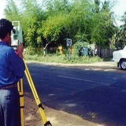
Our professional road survey services deliver comprehensive infrastructure assessment using advanced surveying technologies and international quality standards. We specialize in accurate data collection for pavement conditions, subsurface analysis, utility mapping, and void detection. Our experienced teams utilize state-of-the-art equipment including ground-penetrating radar, laser scanning, and GPS technology to capture precise measurements and detailed information about road infrastructure conditions. We process and deliver data in both digital and hard copy formats tailored to client specifications and project requirements.

Government transportation departments, construction firms, engineering consultants, and municipal authorities across multiple industries rely on our survey services. The construction industry uses our data for new road projects and rehabilitation work, while utility companies depend on our accurate underground mapping for pipeline and cable installations. Engineering firms utilize our detailed assessments for infrastructure design, and municipal governments employ our services for maintenance planning and budget allocation. Transportation authorities trust our surveys for safety compliance and regulatory reporting.

Our road survey services deliver significant business value through risk reduction, cost savings, and enhanced project outcomes. By identifying potential issues like subsurface voids, utility conflicts, and pavement weaknesses early, we help clients avoid costly delays and unexpected expenses. Our reliable data enables informed decision-making, ensures regulatory compliance, and supports optimal resource allocation. Clients benefit from our commitment to quality, timely delivery, and service packages that adapt to specific project needs and challenges.

Key Features:
- Advanced ground-penetrating radar technology for subsurface analysis
- Comprehensive pavement condition assessment and rating systems
- Precise utility mapping with accurate depth and location data
- Professional survey teams with extensive technical expertise
- International quality standard compliance and certification

Benefits:
- Early identification of subsurface voids and potential hazards
- Prevention of utility strikes and construction delays
- Accurate data for informed project planning and budgeting
- Regulatory compliance and safety standard adherence
- Optimized resource allocation and cost-effective solutions
Specifications
| Additional Information | |
|---|---|
| Country of Origin | India |
| Customisable | No |
Application
Our road survey services provide critical infrastructure assessment data for transportation and construction sectors. Government agencies, engineering firms, and municipal authorities rely on our accurate surveys for project planning, maintenance scheduling, and risk mitigation across various development projects. We deliver comprehensive data that supports informed decision-making from initial planning through final construction phases.

Construction companies and infrastructure developers utilize our survey services to identify subsurface conditions, map underground utilities, and assess pavement integrity before beginning projects. Our detailed reports help prevent costly delays, ensure regulatory compliance, and optimize resource allocation for road construction, rehabilitation, and maintenance operations across diverse geographical conditions.
- Highway and road construction project planning and site assessment
- Municipal infrastructure maintenance and rehabilitation programs
- Transportation department safety audits and compliance verification
- Utility companies planning underground cable and pipeline installations
- Engineering consulting firms requiring precise terrain mapping for infrastructure design
Trade Details
| Available Stock | In stock |
| Sample Availability | No |
Payment Terms
| Payment Terms |
|
Company Profile
Eagle Engineers, Pune, Maharashtra
 Maharashtra, India
Services & Support
Factory Details
Factory SizeBelow 1000 sqm
Annual Production Capacity0
Main Markets
North America
South America
Eastern Europe
Southeast Asia
Central America
Road Survey Services For Infrastructure Assessment And Utility Mapping
Professional road survey services deliver precise infrastructure assessment data for pavement conditions, utility mapping, and void detection using advanced techniques and international quality standards.
Min. Order Quantity: 1 units
Shipping
Shipping fee and delivery date to be negotiated. Contact supplier now for more details.
Eagle Engineers, Pune Maharashtra, India
Services & Support