undefined
Apparel & Fashion
Loading subcategories...
View More

Description
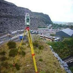
Our Civil Engineering Contour Survey Services deliver professional topographic mapping and terrain analysis using advanced surveying equipment and CAD technology. We provide accura...
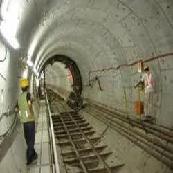
Our Civil Engineering Contour Survey Services deliver professional topographic mapping and terrain analysis using advanced surveying equipment and CAD technology. We provide accurate elevation data and detailed contour lines that serve as the critical foundation for successful land development projects. Following international quality standards, our team ensures reliable results that engineers and project managers can trust for making crucial decisions about infrastructure positioning, grading requirements, and construction feasibility. The service includes comprehensive alignment surveys that determine optimal placement for various project elements, supported by both traditional drawings and modern digital formats for seamless integration into your existing workflow.

These contour surveys serve vital roles across multiple sectors including urban development, transportation infrastructure, mining operations, and environmental management. Civil engineering firms consistently rely on our services for road and highway projects, residential and commercial site development, irrigation system design, and large-scale construction planning. The precise data we generate helps architects, engineers, and project managers make informed decisions regarding grading strategies, drainage solutions, foundation design parameters, and regulatory compliance requirements. Our surveys prove particularly valuable for projects demanding accurate earthwork calculations, thorough slope stability analysis, and comprehensive environmental impact assessments across varied terrains and project complexities.

We deliver exceptional business value through consistently reliable and accurate surveys that significantly reduce project risks and prevent costly errors during construction phases. Our commitment to quality ensures clients receive trustworthy data for critical engineering decisions, while our adaptable approach allows us to meet specific project requirements effectively. The economic feasibility of our services has earned us numerous repeat clients throughout Maharashtra and beyond, demonstrating our consistent delivery of tangible value. Our team's expertise in both traditional surveying methodologies and modern CAD technology provides a comprehensive solution that balances precision with practical implementation considerations for optimal project outcomes.

Key Features:
- International quality standard compliance for all surveying operations
- Advanced CAD design integration with conventional drawing techniques
- Precise topographic mapping with accurate elevation measurements
- Comprehensive alignment surveys for optimal infrastructure positioning
- Detailed terrain analysis including slope and contour calculations

Benefits:
- Reduced project risks through accurate terrain data and analysis
- Prevention of costly construction errors with precise measurements
- Trustworthy data for critical engineering and planning decisions
- Seamless integration with existing project workflows and systems
- Consistent delivery of value across diverse project scales and types
Specifications
| Additional Information | |
|---|---|
| Country of Origin | India |
| Customisable | No |
Application
Our contour survey services provide essential elevation data and terrain mapping for civil engineering projects, enabling accurate land development planning and construction execution. We capture precise topographic details that form the foundation for infrastructure design, earthwork calculations, and regulatory compliance across diverse project scales and terrains.

These surveys support multiple industries by delivering reliable data for grading, drainage solutions, and foundation requirements. Engineers and project managers utilize our detailed contour maps to make informed decisions that optimize construction processes, minimize risks, and ensure projects meet both technical specifications and environmental considerations.
- Road and highway construction planning with precise alignment verification
- Residential and commercial site development including grading plans
- Irrigation system design and comprehensive water management projects
- Mining operations with accurate quarry volume calculations
- Environmental impact assessments and watershed management planning
Trade Details
| Available Stock | In stock |
| Sample Availability | No |
Payment Terms
| Payment Terms |
|
Company Profile
Eagle Engineers, Pune, Maharashtra
 Maharashtra, India
Services & Support
Factory Details
Factory SizeBelow 1000 sqm
Annual Production Capacity0
Main Markets
North America
South America
Eastern Europe
Southeast Asia
Central America
Civil Engineering Contour Survey Services For Topographic Mapping
Professional Civil Engineering Contour Survey Services deliver precise topographic mapping and alignment surveys using CAD designs for reliable land development and infrastructure planning.
Min. Order Quantity: 1 units
Shipping
Shipping fee and delivery date to be negotiated. Contact supplier now for more details.
Eagle Engineers, Pune Maharashtra, India
Services & Support