E Surveying Softech ( India ) Private Limited

Product Range
Fact Sheet
- Location:Karnataka, India
- Year of Establishment:2011
- Business Type:Business Services
- Main Products:Contour Software, Quantity Calculation Software
- Reviews & Rating:

Get Verified, Sell more with
- Buyer's trust
- Faster conversions
- Better Rankings
- More
Its Free
Verify NowEsurvey Topographic Software
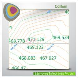
“ESurvey Topodraw” generates Topographical drawings from point data instantly with blocks and elevations in their respective Northing and Easting from the data available in Excel or CSV.
- FOB PriceNA
- Min Order QuantityNA
- Payment TermsNA

Other Details
“ESurvey Topodraw” generates Topographical drawings from point data instantly with blocks and elevations in their respective Northing and Easting from the data available in Excel or CSV.
Key Features:
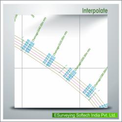
Import point data(Serial Number, Easting, Northing, Elevation, Code) from CSV or Excel for generating Topographical drawing
Import predefined or newly defined blocks automatically while creating drawing
Export codes point data in different layer selectively
Create Total station data from CAD drawing
Selectively Auto Connect codes in CAD
Benefits:
Save considerable time while generating drawing from field data.
Detailed Layerised Output helps to process the drawing easily.
Images