Balaji Geotrak Technowizard Private Limited

- Products
- Topographic-Survey
- GIS And Remote Sensing Services
Product Range
Fact Sheet
- Location:Uttar Pradesh, India
- Year of Establishment:2005
- Business Type:Business Services
- Turnover:Rs. 50 Lakh - 5 Crore
(or USD 100 K - 1 Million) - Main Products:Topographic Survey, Training Services
- Reviews & Rating:

Get Verified, Sell more with
- Buyer's trust
- Faster conversions
- Better Rankings
- More
Its Free
Verify NowGIS And Remote Sensing Services
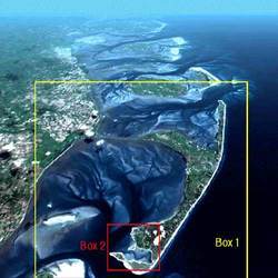
Our remote GIS and Remote Sensing Services is being rendered by using ERDAS software. Our ERDAS software is used for image processing for extracting, developing, processing and analyzing remotely sensed data in digital mode.
- FOB PriceNA
- Min Order QuantityNA
- Payment TermsNA

Other Details
Our remote GIS and Remote Sensing Services is being rendered by using ERDAS software. Our ERDAS software is used for image processing for extracting, developing, processing and analyzing remotely sensed data in digital mode. We have a team of technocrats and engineers who ensure that the process goes in compliance with the ISO and CMM standards.
Images