Balaji Geotrak Technowizard Private Limited

- Company Info
Company Overview

Fact Sheet
- Location:Uttar Pradesh, India
- Year of Establishment:2005
- Business Type:Business Services
- Turnover:Rs. 50 Lakh - 5 Crore
(or USD 100 K - 1 Million) - Main Products:Topographic Survey, Training Services
- Reviews & Rating:

Get Verified, Sell more with
- Buyer's trust
- Faster conversions
- Better Rankings
- More
Its Free
Verify NowCompany Info
Overview
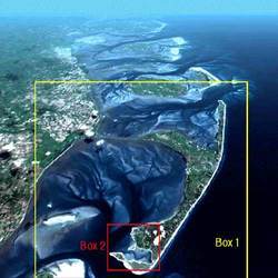
Established in the year 2007, Balaji Geotrak Technowizard (P) Ltd. is an IT-enabled services company having expertise in the field of GIS (Geographical Information Systems). We have our core expertise in the field of Geo-Informatics, Digital Aerial Terrestrial and Architectural Photogrammetry. Apart from this, we also extend our services like professional architect services, residential architect services, commercial architect services, etc., in LiDAR Processing, Surveying, Mapping GIS to support the geospatial needs of public-and private-sector customers worldwide.
We provide digital maps of cities, states and countries in variety of data formats with associated software. Along with these, our clients are offered with off-the-shelf information system with complete spatial and non-spatial database of major Indian cities for Sales & Marketing, Logistics Management, Urban Planning, Law enforcement, Insurance, Banking, Site Analysis & solutions, Dealer Network, Detailed Executive Information network, Road network, Courier & Cargo management supporting network, Better market penetration, Rural Marketing, Target Marketing, Sales analysis, Distribution logistics, Market segment analysis, Territory planning analysis, Professional Architect Services, Residential Architect Services, Commercial Architect Services, Plantation Management and Merchandise planning.
We are equipped with all the latest facilities, which enable us to provide our clients with efficient and prompt consultancy services like professional architect services, residential architect services, commercial architect services, etc. We also have expertise in converting large volumes of paper maps, drawing and documents with fast turn around time. We have ability to manage complex conversion projects, which require conversion of data from multiple scales and quality. Moreover, we also handle combinations of topographic maps, CAD drawings, Satellite imageries, Aerial photographs or Data collected through advance field survey equipment. Our integrated process for conversion includes scanning, digitizing, data layering, geo-positioning and QA/QC to get the final output.
Application Area
Our wide range of consultancy services is being extensively used by our clients across various industries. The various areas where our services find their application are the following:
Geographical Information Systems
Automated Mapping (AM)
Facilities Management (FM)
Computer Aided Design (CAD)
Digital Cartography
Business GIS
Executive Information System
Domain Expertise
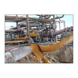
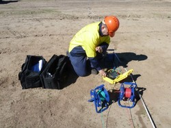
We have been able to grow leaps and bounds due to the strong hold on our domain of work. This has been possible because we have all the requisite facilities to undertake value added services for Topographic Survey, Geotechnical Engineering Investigation, Software Engineering Development, Remote Sensing & Satellite Imaging, Urban Planners & Architects, Training in CAD & GIS, Gas Pipe Line Surveying, Electrical Engineering Transmission Line Survey and other allied services. We integrate precision survey data collected through latest survey equipments such as Differential Global Positioning System (DGPS).
We have adequate infrastructure and equipment like Global Positioning System (Garmin) and Total Survey Stations (Topcon & Geodimeter). We then integrate the same with latest satellite data and bring them on a GIS platform, which will work for various applications as a Decision Support System. We truly believe the fact that we need to understand the particular project may require specific technical skills or platforms. Thus, our skill set has comprehensive range of languages and technologies.
GIS MapInfo, Map basic, ArcGIS, AutoCAD Map, Eradas Imagine.
Database - Oracle 9i, SQL Server, DB2, MS Access
OS platform - Windows 98, Windows NT, Windows XP, Windows CE
Programming Languages - Java, C, C++, VC++, Visual Basic, Map
Basic, LISP