undefined
Land Survey & Demarcation
20 products available
𝗪𝗵𝗮𝘁 𝗮𝗿𝗲 𝗟𝗮𝗻𝗱 𝗦𝘂𝗿𝘃𝗲𝘆 & 𝗗𝗲𝗺𝗮𝗿𝗰𝗮𝘁𝗶𝗼𝗻?
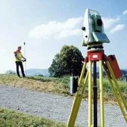
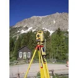
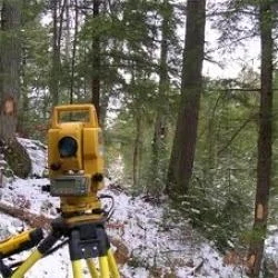
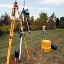
Land survey and demarcation refer to the processes involved in defining the boundaries of a specific parcel of land. This practice involves measuring and mapping land to determine its dimensions, features, and boundaries accurately. Surveys can involve various techniques and technologies, including traditional methods and advanced equipment such as GPS and drones. Demarcation, on the other hand, is the physical marking of these boundaries on the land itself, often using stakes, fences, or other markers.
These services are crucial for a variety of applications, including real estate development, property disputes, and land use planning. Businesses that require precise land measurements rely on these services to ensure compliance with legal requirements and to avoid potential conflicts. As urbanization and land development continue to grow, the relevance of land survey and demarcation services in facilitating orderly development and enhancing property value becomes increasingly significant.
The market for land survey and demarcation is expanding, driven by the construction and real estate sectors. With the increasing complexity of land ownership and usage rights, accurate surveying becomes essential for legal and commercial purposes. This industry serves various stakeholders, including architects, engineers, and local governments, highlighting its importance in modern infrastructure development.
𝗞𝗲𝘆 𝗙𝗲𝗮𝘁𝘂𝗿𝗲𝘀 𝗮𝗻𝗱 𝗦𝗽𝗲𝗰𝗶𝗳𝗶𝗰𝗮𝘁𝗶𝗼𝗻𝘀
Land survey and demarcation services come with several key features that enhance their effectiveness and reliability. These specifications are vital for ensuring accurate results and meeting the diverse needs of clients.
Key specifications include:
1. Measurement Accuracy
- Precision in land measurements is crucial.
- Typically, accuracy is within a few centimeters.
2. Boundary Definition
- Clear delineation of property lines.
- Involves both physical markers and detailed mapping.
3. Use of Technology
- Integration of GPS and GIS systems in surveys.
- Utilizes drones for aerial assessments as needed.
4. Reporting Standards
- Detailed reports provided post-survey.
- Must comply with local regulations and standards.
5. Survey Types
- Various survey types offered: topographic, boundary, and ALTA/NSPS surveys.
- Tailored to meet specific project requirements.
6. Compliance with Legal Requirements
- Surveys must adhere to local land use laws.
- Essential for legal documentation and land transactions.
7. Expert Personnel
- Services provided by trained and certified surveyors.
- Continuous professional development to keep up with industry standards.
8. Geographic Information System (GIS) Integration
- Data is often integrated into GIS for better analysis.
- Allows for visual representation and planning.
In summary, the effectiveness of land survey and demarcation services is largely dependent on accuracy and compliance with established standards. These features are essential for any business seeking reliable land measurement and demarcation solutions.
𝗖𝗼𝗺𝗺𝗼𝗻 𝗔𝗽𝗽𝗹𝗶𝗰𝗮𝘁𝗶𝗼𝗻𝘀 𝗮𝗻𝗱 𝗨𝘀𝗲 𝗖𝗮𝘀𝗲𝘀
Land survey and demarcation services find applications across various industries, reflecting their versatility and necessity.
1. Real Estate Development: Accurate surveys are critical in determining property boundaries for new developments, ensuring compliance with zoning laws, and facilitating the sale of land.
2. Construction: Surveying provides essential data needed for construction projects, helping to determine site layouts and ensuring structures are built within legal boundaries.
3. Agriculture: Farmers use land surveying to optimize land use, manage crops effectively, and plan irrigation systems based on accurate land measurements.
4. Environmental Management: Surveys help in assessing land for environmental impacts and managing natural resources by providing precise data about land topography and features.
5. Government and Infrastructure: Local governments rely on surveys for urban planning, road construction, and public works projects to ensure that developments meet legal and community standards.
6. Legal Disputes: Land surveys are often used as critical evidence in property disputes, clarifying boundaries and ownership rights.
7. Mining and Resource Extraction: Surveys are essential for assessing land for resource extraction, helping companies to understand the land’s potential and legal boundaries.
𝗣𝗿𝗼𝗱𝘂𝗰𝘁 𝗩𝗮𝗿𝗶𝗮𝗻𝘁𝘀 𝗮𝗻𝗱 𝗦𝘂𝗯𝗰𝗮𝘁𝗲𝗴𝗼𝗿𝗶𝗲𝘀
Land survey and demarcation services may offer various approaches to meet different needs and requirements.
Traditional Land Surveying
This involves manual measurements and physical markers for defining boundaries. It is often used in rural settings or where advanced technology is not feasible.
Digital Land Surveying
Utilizing modern technology such as GPS and GIS, this variant offers more precise measurements and quicker results. It is applicable in urban areas where accuracy is paramount.
Topographic Surveys
These surveys focus on the terrain and physical features of a land area. They are used in construction and landscaping projects to create detailed maps.
Boundary Surveys
Focusing specifically on property lines, boundary surveys are essential for legal documentation and resolving disputes.
𝗕𝗲𝗻𝗲𝗳𝗶𝘁𝘀 𝗮𝗻𝗱 𝗔𝗱𝘃𝗮𝗻𝘁𝗮𝗴𝗲𝘀
Land survey and demarcation services provide numerous advantages that contribute to effective land management and development.
Key benefits include:
1. Increased Accuracy: Professional surveys offer precise measurements that reduce the chance of disputes and errors in land use.
2. Legal Compliance: Ensures adherence to local regulations and laws, protecting businesses and property owners from legal issues.
3. Enhanced Planning: Accurate data enables better planning and decision-making in construction, agriculture, and urban development.
4. Conflict Resolution: Surveys provide clear evidence of property boundaries, helping to resolve disputes amicably.
5. Increased Property Value: Well-defined boundaries can enhance property value by clarifying ownership and reducing ambiguities.
6. Improved Safety: Accurate surveys ensure that construction and development projects are carried out safely and within designated areas.
𝗕𝘂𝘆𝗶𝗻𝗴 𝗚𝘂𝗶𝗱𝗲 𝗳𝗼𝗿 𝗕𝟮𝗕 𝗕𝘂𝘆𝗲𝗿𝘀
When sourcing land survey and demarcation services, it is essential to consider several key factors to ensure a successful partnership.
1. Quality Assessment: Look for firms with a proven track record of accuracy and reliability. Check client testimonials and past project outcomes.
2. Supplier Verification: Vet potential suppliers thoroughly. Ensure they have the necessary certifications and licenses to operate in your region.
3. Pricing and MOQ: Understand the pricing structure and any minimum order quantities. Cost-effectiveness is crucial but should not compromise quality.
4. Delivery and Lead Times: Consider how quickly suppliers can deliver services. Timely completion of surveys is critical for project schedules.
5. Compliance Requirements: Ensure that the supplier adheres to all relevant legal and regulatory standards in your area. This protects your investment and ensures project legitimacy.
𝗖𝗼𝗺𝗽𝗹𝗶𝗮𝗻𝗰𝗲 𝗮𝗻𝗱 𝗖𝗲𝗿𝘁𝗶𝗳𝗶𝗰𝗮𝘁𝗶𝗼𝗻𝘀
Land survey and demarcation services must adhere to various quality standards and certifications to ensure reliability and safety.
Relevant quality standards include ISO 9001, which outlines requirements for a quality management system, ensuring consistent service delivery. Compliance with HACCP and GDP may also be necessary in specific applications where health and safety are concerns.
Industry certifications, such as CE marking, indicate that products and services meet EU safety, health, and environmental protection standards.
Additionally, safety testing requirements must be met to ensure that all equipment used in surveying is reliable and does not pose risks during operation.
Regional compliance considerations are also vital, as different areas may have unique regulations governing land use and surveying practices.
𝗪𝗵𝘆 𝗦𝗼𝘂𝗿𝗰𝗲 𝗟𝗮𝗻𝗱 𝗦𝘂𝗿𝘃𝗲𝘆 & 𝗗𝗲𝗺𝗮𝗿𝗰𝗮𝘁𝗶𝗼𝗻 𝗳𝗿𝗼𝗺 𝗣𝗲𝗽𝗮𝗴𝗼𝗿𝗮?
Pepagora offers a trusted platform for sourcing land survey and demarcation services, providing several key advantages for B2B buyers.
Verified Supplier Network: Pepagora has established a rigorous verification process for suppliers, ensuring that they possess the necessary certifications and expertise. This builds confidence for businesses looking to partner with reliable providers.
Streamlined RFQ Process: The request for quotation system is designed to simplify the procurement process. Buyers can easily submit their requirements and receive competitive quotes from multiple suppliers, allowing for informed decision-making.
Trade Assurance and Support: Pepagora prioritizes buyer protection through trade assurance programs. This helps mitigate risks associated with procurement, ensuring that businesses receive the quality and service they expect.
Regional Coverage: With a focus on markets in India, the GCC, and Southeast Asia, Pepagora provides extensive geographic reach. This regional focus ensures that buyers have access to local suppliers who understand the specific requirements of their markets.
In conclusion, Pepagora is positioned as a reliable partner for businesses seeking land survey and demarcation services, combining a verified supplier network, efficient processes, and strong buyer support.
Newly Added


Recently Added
Hi-Tech India
Industrial Metrology Precision Measurement Tools For Quality Control
Civil Engineering Lab Equipment For Water Treatment And Soil Analysis
Miscellaneous Items For Business Operations And Supplies
Hitech India Pvt Ltd
Computerised Universal Testing Machine TUE C for Material Testing
SMS Structural Fabrication Equipment Punching Drilling Shearing Beam Processing
Universal Testing Machine TUE CN for Tensile Compression Flexural Strength
A One Associates
Professional Total Station Land Survey Services For Construction And Mining
Professional Topographical Land Survey Services For Accurate Terrain Mapping
Powerline Survey Services Real Time Data Plotting Quality Checks
Dhyani Consultants Inc.
High Transmission Line Survey Services For Electrical Infrastructure
Professional Route Survey Services For Highway Pipeline Canal Railroad Construction
Professional Road Survey Services For Pavement And Sublayer Assessment
Alpha Engineering Equipments
Electronic Theodolites For Surveying And Construction Professionals
Premium Bitumen Testing Machines For Construction Materials Analysis
Aggregate Testing Machines For Construction Materials Analysis
Eagle Engineers, Pune
Road Survey Services For Infrastructure Assessment And Utility Mapping
Professional Civil Engineering Survey Services For Accurate Land Mapping
Professional Plane Table Surveying Services For Accurate Land Mapping
B. E. P. Edu World
Child CPR Training Manikin with Light Indicators for Medical Education
Nurse Basic Practice Teaching Model BEP 405 5 Part Anatomical Training Tool
CPR Training Manikin with Electronic Monitoring Meets AHA Standards
Hitech India Equipments Pvt.Ltd
Precision Surveying Instruments For Construction And Mining With Glass
Hydraulic Tensile Testing Machine With NABL Calibration For
Premium Asphalt Bitumen Testing Equipment High Tensile Metal OEM
Best Surveyors & Valuers Private Limited
Professional Property Valuation Services For Commercial And Industrial Assets
Business Project Report Preparation Service for Funding and Compliance
Business Project Report Preparation Service For Funding And Approvals
D. Vyas & Associates
Architectural Design Services For Residential Commercial Industrial Projects
Architectural Consultancy Services For Commercial Industrial Institutional Projects
Professional Valuation Consultancy Services For Real Estate And Business Assets
Why Businesses Trust Pepagora
Thousands of companies trust Pepagora to source smarter and sell faster
Expand Your Sales Globally
25000+Products listed.Get discovered by global buyers
Tools to boost visibility
Build your own catalog

Source Smarter,Grow Faster
4000+Active RFQs
100+ Countries served
Easy Sourcing Tools
