undefined
Similar Products


Description
Our professional topographical land survey services deliver precise terrain mapping and comprehensive site analysis for businesses requiring accurate spatial data. We specialize in...
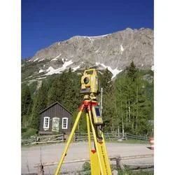
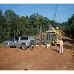
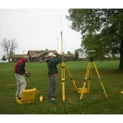
Our professional topographical land survey services deliver precise terrain mapping and comprehensive site analysis for businesses requiring accurate spatial data. We specialize in detailed land surveying that captures natural and man-made features, elevation changes, and ground characteristics through advanced measurement techniques. Our team utilizes state-of-the-art equipment including GPS systems, total stations, and laser scanning technology to ensure high accuracy in data collection. This foundational geographic information serves as critical input for engineering design, construction planning, and infrastructure development projects. We maintain strict quality control protocols throughout the survey process, from initial site assessment to final data delivery, ensuring clients receive reliable and actionable information for their projects.

Topographical land surveys find extensive application across multiple industries including construction, civil engineering, mining, urban planning, and environmental management. Construction companies rely on our surveys for site planning, foundation design, and earthwork calculations while civil engineering firms use the data for road design, drainage planning, and infrastructure development. Mining operations utilize topographic surveys for volume calculations, pit design, and compliance monitoring while urban planners depend on accurate terrain data for zoning decisions and development approvals. Environmental consultants employ our surveys for habitat mapping, erosion control planning, and environmental impact assessments. The versatility of topographical data makes it indispensable for any project involving land development or terrain modification.

Our topographical survey services deliver significant business value through accurate data that reduces project risks, minimizes costly errors, and ensures regulatory compliance. The reliability of our surveys comes from experienced surveyors, quality-controlled processes, and advanced technology that consistently produces precise results. Clients benefit from reduced project delays, optimized resource allocation, and improved decision-making capabilities based on trustworthy spatial information. The long-term value of our surveys extends beyond initial project planning to support ongoing operations, maintenance planning, and future expansion considerations while ensuring projects proceed with confidence and accuracy.

Key Features:
- Advanced GPS and total station technology for high accuracy data collection
- Comprehensive terrain mapping including elevation, contours, and physical features
- Detailed site analysis capturing natural and man-made characteristics
- Experienced professional surveyors with industry-specific expertise
- Strict quality control protocols ensuring data reliability and precision

Benefits:
- Reduced project risks through accurate terrain data and analysis
- Minimized costly errors in planning and construction phases
- Improved decision-making capabilities with reliable spatial information
- Regulatory compliance support through detailed site documentation
- Long-term value for ongoing operations and future expansion planning
Specifications
| Additional Information | |
|---|---|
| Country of Origin | India |
| Customisable | No |
Application
Topographical land surveys provide essential terrain data for construction planning, infrastructure development, and engineering projects. These surveys accurately map elevation changes, natural features, and ground characteristics that form the foundation for safe and efficient project execution across various industries. Our professional survey services adapt to diverse project requirements, from residential developments to industrial complexes, ensuring precise data collection regardless of terrain challenges or project scale.

Professional topographic mapping serves critical roles in urban development, civil engineering, mining operations, and environmental planning. The detailed terrain information enables accurate earthwork calculations, proper drainage design, and optimal infrastructure placement. These surveys also support regulatory compliance by documenting existing site conditions and providing baseline data for environmental assessments and development approvals across multiple sectors.
- Construction site planning and development feasibility analysis
- Road and highway design with precise gradient and elevation data
- Mining operations for volume calculations and pit design optimization
- Flood risk assessment and drainage system planning
- Telecommunications infrastructure placement and network development
Trade Details
| Available Stock | In stock |
| Sample Availability | No |
Payment Terms
| Payment Terms |
|
Company Profile
A One Associates, Punjab
 Punjab, India
Factory Details
Factory SizeBelow 1000 sqm
Annual Production Capacity0
Professional Topographical Land Survey Services For Terrain Mapping
Professional topographical land survey services deliver precise terrain mapping for construction, engineering, and infrastructure projects. Accurate elevation data and reliable site analysis support informed planning decisions.
Min. Order Quantity: 1 units
Shipping
Shipping fee and delivery date to be negotiated. Contact supplier now for more details.
A One Associates Punjab, India