undefined
Similar Products


Description
Our professional topographic land survey services provide the accurate mapping and detailed terrain intelligence required for successful project execution. We specialize in capturi...
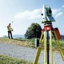
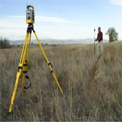
Our professional topographic land survey services provide the accurate mapping and detailed terrain intelligence required for successful project execution. We specialize in capturing the precise contours, elevations, and physical characteristics of a land surface, translating the real world into reliable, actionable data. Using advanced surveying technology and methodologies, our team delivers comprehensive topographic maps that detail both natural features like hills, valleys, and waterways, and man-made structures such as buildings, roads, and utilities. This meticulous documentation forms the critical groundwork for planning, design, and regulatory compliance, ensuring every project starts with a clear and accurate understanding of the site.

These services are fundamental across industries where the land itself is a primary project component. Construction and development firms depend on our surveys for site feasibility studies, earthwork calculations, and creating precise grading plans. Engineering consultants utilize our data to design infrastructure networks, including transportation systems, utilities, and flood control measures. The mining and aggregates sector relies on our accurate volume measurements for resource management and operational planning. Furthermore, government agencies and environmental planners use our detailed maps for zoning, land-use decisions, and monitoring ecological changes, making our work a cornerstone for both economic development and responsible land stewardship.

The business value of our topographic surveys lies in their power to mitigate risk, prevent costly errors, and optimize project outcomes. By providing a true and complete picture of site conditions, we enable our clients to design with confidence, avoid unexpected obstacles, and streamline the construction process. Our commitment to reliability and precision translates directly into cost savings, schedule adherence, and regulatory assurance. We differentiate ourselves through a steadfast focus on quality, the expertise of our seasoned surveyors, and our ability to deliver consistently accurate data that serious buyers and project stakeholders can trust implicitly for making significant investment and development decisions.

Key Features:
- Utilization of advanced surveying equipment including GPS, total stations, and laser scanning for high-precision data capture.
- Detailed mapping of all terrain contours, elevation points, slopes, and natural land features.
- Comprehensive documentation of existing site conditions, including buildings, roads, fences, and utilities.
- Delivery of data in multiple formats, including CAD-ready files, contour maps, and digital terrain models (DTMs).
- Execution by a professional, experienced team skilled in complex site analysis and survey methodology.

Benefits:
- Reduces project risk and prevents costly surprises by revealing accurate site conditions before design and construction.
- Provides the essential data needed for precise engineering design, earthwork calculations, and regulatory submissions.
- Saves time and money by enabling efficient planning and minimizing rework due to inaccurate site information.
- Enhances decision-making with reliable, detailed maps that support feasibility studies and investment analysis.
- Delivers a trusted foundation for project success, ensuring designs are buildable and compliant with site realities.
Specifications
| Additional Information | |
|---|---|
| Country of Origin | India |
| Customisable | No |
Application
Our topographic land survey services provide essential, accurate data for informed project planning and execution. We map natural terrain, elevation changes, and existing features to create a reliable foundation for design and development, helping professionals understand site conditions before work begins.

These detailed surveys are critical for multiple industries that rely on precise land data. From initial site assessment to final design validation, our services help identify potential challenges, optimize solutions, and ensure projects account for real-world terrain, ultimately saving time and reducing unforeseen costs during construction and development.
- Construction site planning, grading design, and foundation layout for new buildings and developments.
- Civil engineering projects including road, highway, bridge, and drainage system design and alignment.
- Land development and subdivision planning for residential, commercial, and industrial zones.
- Mining, quarrying, and resource extraction operations for precise volume calculations and pit planning.
- Environmental management, conservation planning, and landscape change monitoring.
Trade Details
| Available Stock | In stock |
| Sample Availability | No |
Payment Terms
| Payment Terms |
|
Company Profile
Dhyani Consultants Inc., New Delhi
 New Delhi, India
Electronics & Electrical•Distributor / WholesalerRetailerImporter / Exporter
Factory Details
Factory SizeBelow 1000 sqm
Annual Production Capacity0
Professional Topographic Land Survey Services For Accurate Mapping
Professional topographic land survey services deliver accurate mapping and detailed terrain data for construction, engineering, and infrastructure projects. Our precise surveys support reliable project planning and development.
Min. Order Quantity: 1 units
Shipping
Shipping fee and delivery date to be negotiated. Contact supplier now for more details.
Dhyani Consultants Inc. New Delhi, India
Electronics & ElectricalDistributor / Wholesaler