undefined

Similar Products


Description
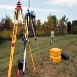
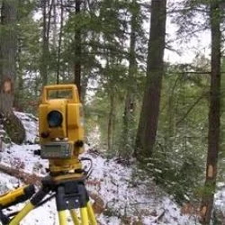
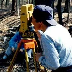
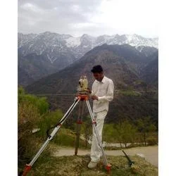
Our professional surveyor services deliver comprehensive land and construction surveying solutions designed to meet the diverse needs of infrastructure, real estate, and industrial...
Our professional surveyor services deliver comprehensive land and construction surveying solutions designed to meet the diverse needs of infrastructure, real estate, and industrial projects. With an unwavering focus on accuracy and reliability, we provide detailed topographic, boundary, and engineering surveys using advanced tools and proven methodologies. These services ensure that projects are built on precise data, significantly reducing errors while enhancing operational efficiency. Whether for small-scale property assessments or large infrastructure initiatives, our team delivers customized surveys that align with client specifications and industry standards, supporting informed decision-making and project success from conception to completion.

These surveyor services are extensively utilized across multiple industries, including construction where they facilitate precise site planning and foundation work, and real estate for accurate boundary identification and development projects. The infrastructure sector relies on our surveys for road networks, pipeline installations, and urban development initiatives. Additionally, sectors such as mining, agriculture, and environmental management depend on our expertise for comprehensive terrain analysis, resource mapping, and ensuring compliance with regulatory requirements. This broad applicability makes our services indispensable for businesses aiming to optimize project outcomes while maintaining strict adherence to legal and safety standards across various operational environments.

The business value of our surveyor services lies in their proven ability to enhance project accuracy, reduce costly errors, and ensure full regulatory compliance, directly impacting project timelines and budgets. Clients benefit from reliable data that supports effective risk mitigation and efficient resource allocation, leading to smoother project execution and higher return on investment. Our differentiation stems from our commitment to quality, customization options that address unique project needs, and a demonstrated track record of delivering trustworthy results. This reliability fosters long-term partnerships, making us the preferred choice for businesses seeking dependable survey solutions that consistently meet their project requirements and quality expectations.

Key Features:
- Accurate land and topographic surveys using advanced measurement technologies
- Customizable survey solutions tailored to specific project requirements
- Comprehensive boundary and engineering surveys for legal and construction needs
- Detailed reporting and mapping with clear, actionable data outputs
- Adherence to industry standards and regulatory compliance in all surveys

Benefits:
- Enhanced project accuracy through precise data collection and analysis
- Reduced operational risks and minimized costly errors during project execution
- Improved regulatory compliance and adherence to safety standards
- Optimized resource allocation and better project planning capabilities
- Increased return on investment through efficient project implementation
Specifications
| Additional Information | |
|---|---|
| Country of Origin | India |
| Customisable | No |
Application
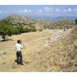
Our surveyor services provide accurate land measurement and mapping for infrastructure development, including roads, pipelines, and urban planning. We deliver detailed topographic data essential for construction projects, ensuring precise groundwork and compliance with design specifications. These services support environmental assessments and resource management by mapping terrains and monitoring changes over time.

Survey solutions are critical for real estate development, facilitating boundary demarcation, site planning, and legal documentation. Industries such as mining, agriculture, and telecommunications rely on our expertise for terrain analysis, asset mapping, and project feasibility studies. Our surveys help businesses mitigate risks, optimize resource allocation, and adhere to regulatory standards efficiently.
- Conducting boundary surveys for property transactions and development projects
- Providing topographic mapping for infrastructure planning like roads and utilities
- Supporting construction layouts with precise measurements for building foundations
- Enabling environmental monitoring through land change detection and mapping
- Assisting in mining operations with volume calculations and site exploration
Trade Details
| Available Stock | In stock |
| Sample Availability | No |
Payment Terms
| Payment Terms |
|
Company Profile
Best Surveyors & Valuers Private Limited, West Bengal
 West Bengal, India
Services & Support
Factory Details
Factory SizeBelow 1000 sqm
Annual Production Capacity0
Professional Surveyor Services For Land Construction Topographic Surveys
Professional surveyor services deliver precise land, construction, and topographic surveys for infrastructure, real estate, and industrial projects with reliable, customized solutions.
Min. Order Quantity: 1 units
Shipping
Shipping fee and delivery date to be negotiated. Contact supplier now for more details.
Best Surveyors & Valuers Private Limited West Bengal, India
Services & Support