undefined

Similar Products


Description
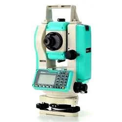
Professional surveying instruments represent the pinnacle of measurement technology, engineered for exceptional accuracy and reliability in demanding field conditions. These advanc...
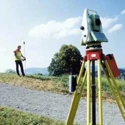
Professional surveying instruments represent the pinnacle of measurement technology, engineered for exceptional accuracy and reliability in demanding field conditions. These advanced tools include total stations, GPS systems, levels, and laser scanners that provide precise spatial data for engineering and construction requirements. Modern instruments feature sophisticated optics, electronic distance measurement, and integrated data collection systems that streamline fieldwork while maintaining rigorous accuracy standards. The technology enables professionals to capture detailed terrain information, establish precise coordinates, and create comprehensive digital models for project planning and execution with confidence in every measurement.

Surveying instruments serve essential roles across multiple professional sectors including civil engineering, construction, mining, and urban development. Civil engineers depend on these tools for infrastructure projects, road construction, and bridge building applications. The construction industry utilizes surveying equipment for site preparation, foundation work, and structural alignment tasks. Mining operations rely on precise measurements for volume calculations and excavation design, while environmental professionals use these instruments for land management and conservation initiatives. Government entities employ surveying technology for cadastral mapping and public works development programs.

Investing in professional surveying instruments delivers substantial value through improved project accuracy, reduced rework expenses, and enhanced operational efficiency. These tools provide dependable performance through rugged construction, environmental resistance, and long-term calibration stability. The equipment's durability ensures consistent operation in challenging conditions, while advanced features like wireless connectivity and automated tracking increase productivity. Professional surveying instruments represent a strategic investment that yields returns through precise project delivery, regulatory adherence, and client confidence in measurement outcomes.

Key Features:
- High-precision angular and distance measurement capabilities
- Durable construction with environmental and impact resistance
- Advanced GPS and GNSS integration for positioning accuracy
- Robotic automation enabling efficient single-person operation
- Extended-range laser scanning with comprehensive data collection

Benefits:
- Exceptional measurement accuracy reducing project errors
- Reliable performance in demanding environmental conditions
- Enhanced positioning precision with satellite technology integration
- Increased operational efficiency through automated functions
- Comprehensive data capture for detailed project documentation
Specifications
| Additional Information | |
|---|---|
| Country of Origin | India |
| Customisable | No |
Application
These precision surveying instruments provide essential measurement capabilities for construction site preparation, infrastructure development, and land assessment projects. They deliver accurate data for mapping, boundary establishment, and elevation determination across diverse terrains and project scales, enabling professionals to create detailed surveys and ensure engineering specification compliance throughout project lifecycles.

Modern surveying equipment serves critical functions in urban development, transportation projects, and environmental assessment. Advanced technologies including GPS integration, laser scanning, and robotic systems deliver unmatched accuracy for large-scale infrastructure work. These instruments support construction monitoring, volume calculations, and verification processes while maintaining strict quality control standards across various professional applications.
- Construction site layout and building foundation alignment
- Road and highway engineering with precise grade control
- Land subdivision and property boundary determination
- Mining operations for volume measurement and pit mapping
- Archaeological site documentation and preservation mapping
Trade Details
| Available Stock | In stock |
| Sample Availability | No |
Payment Terms
| Payment Terms |
|
Company Profile

Hitech India Pvt Ltd, Andhra Pradesh
 Andhra Pradesh, India
ManufacturerImporter / Exporter
Factory Details
Factory SizeBelow 1000 sqm
Annual Production Capacity0
Professional Surveying Instruments For Accurate Land Measurement And Construction
Professional surveying instruments deliver high-precision land measurement and construction layout with superior reliability for engineers and surveyors requiring accurate topographic mapping and boundary establishment.
Min. Order Quantity: 1 units
Shipping
Shipping fee and delivery date to be negotiated. Contact supplier now for more details.
Hitech India Pvt Ltd Andhra Pradesh, India
Manufacturer