undefined

Similar Products


Description
Our State Highway Road Survey Services deliver comprehensive infrastructure assessment solutions using advanced surveying equipment and proven methodologies. We provide precise dat...
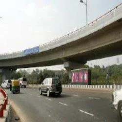
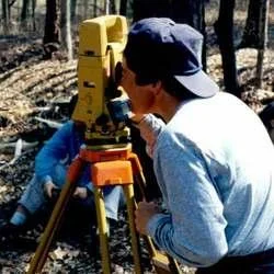
Our State Highway Road Survey Services deliver comprehensive infrastructure assessment solutions using advanced surveying equipment and proven methodologies. We provide precise data collection including topographic mapping, alignment analysis, and condition evaluations that meet national highway standards. Our certified team ensures accurate measurements and detailed reporting that forms the foundation for successful highway projects. This professional approach reduces project risks and ensures reliable data from initial planning through final implementation, supporting infrastructure development with confidence and precision.

These surveying services are essential for government transportation departments managing highway networks and infrastructure upgrades. Civil engineering firms rely on our accurate data for design development and construction planning, while infrastructure development companies use our surveys for project feasibility assessments. Environmental agencies utilize our comprehensive reports for compliance documentation, and municipal planning departments depend on our detailed mapping for urban development projects involving highway connectivity and transportation planning.

We deliver significant business value through reliable, accurate surveying that prevents costly errors and project delays. Our services help clients avoid budget overruns by providing precise data upfront, enabling informed decision-making and proper resource allocation. The consistent quality and attention to detail ensure each survey meets specific project requirements while maintaining competitive pricing. This reliability makes us the preferred partner for critical infrastructure projects, delivering cost-effective solutions without compromising accuracy or compliance standards.

Key Features:
- Advanced topographic mapping using GPS and drone technology for precise measurements
- Comprehensive alignment studies and route optimization analysis
- Detailed road condition assessment and structural evaluation reporting
- Regulatory compliance documentation and environmental impact assessments
- High-precision data collection meeting national highway standards

Benefits:
- Prevents costly project errors and construction delays through accurate data
- Supports informed decision-making with reliable infrastructure planning information
- Ensures regulatory compliance and environmental standards adherence
- Enables efficient resource allocation and budget management
- Provides comprehensive documentation for project approvals and funding
Specifications
| Additional Information | |
|---|---|
| Country of Origin | India |
| Customisable | No |
Application
Our state highway road survey services provide essential infrastructure planning data through precise topographic mapping, alignment studies, and condition assessments. We utilize advanced surveying technology to ensure accurate measurements that meet regulatory standards and support comprehensive project planning from initial concept through final implementation. This detailed approach guarantees reliable data collection for all highway development and improvement initiatives.

These services support government transportation departments, construction companies, and engineering consultants in making informed decisions about highway projects. Our surveys facilitate route optimization, land acquisition planning, and environmental compliance documentation. The accurate data helps stakeholders identify potential challenges early and develop effective solutions that maintain project timelines and budget constraints.
- Highway expansion projects requiring precise land measurements and boundary mapping
- New highway construction planning including route feasibility and alignment studies
- Road condition assessment and maintenance planning for existing state highways
- Traffic flow analysis and intersection improvement projects for enhanced safety
- Environmental impact assessments and regulatory compliance documentation
Trade Details
| Available Stock | In stock |
| Sample Availability | No |
Payment Terms
| Payment Terms |
|
Company Profile
Creative Engineering Services, Uttar Pradesh
 Uttar Pradesh, India
Factory Details
Factory SizeBelow 1000 sqm
Annual Production Capacity0
State Highway Road Survey Services For Infrastructure Planning
Professional State Highway Road Survey Services deliver precise infrastructure planning data using advanced technology for accurate route mapping, compliance reporting, and cost-effective project development.
Min. Order Quantity: 1 units
Shipping
Shipping fee and delivery date to be negotiated. Contact supplier now for more details.
Creative Engineering Services Uttar Pradesh, India