undefined
Similar Products


Description
Solar Energy Map provides comprehensive solar resource data and geographical analysis specifically designed for professional solar energy development projects. This advanced mappin...
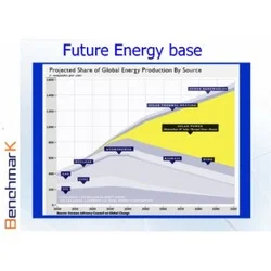
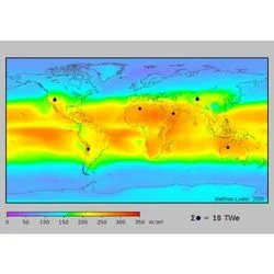
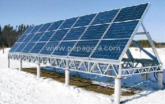
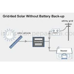
Solar Energy Map provides comprehensive solar resource data and geographical analysis specifically designed for professional solar energy development projects. This advanced mapping platform delivers accurate solar irradiance measurements, historical weather patterns, and terrain analysis to determine optimal solar installation sites. The system offers customizable data layers including global horizontal irradiance, direct normal irradiance, and diffuse horizontal irradiance, enabling precise energy yield predictions and performance modeling. Developed for professional users, it incorporates the latest satellite data and meteorological information to ensure reliability across diverse geographical regions and varying climate conditions.

This solar mapping solution serves multiple professional sectors including renewable energy development, engineering and construction services, agricultural planning, and government energy departments. Utility companies utilize it for large-scale solar farm site selection and capacity planning, while engineering contractors rely on it for commercial and industrial rooftop project assessments. Agricultural operations implement these maps for solar-powered irrigation system planning, and academic institutions utilize them for renewable energy research and curriculum development. Government agencies employ solar energy maps for policy planning, renewable energy target setting, and public infrastructure development projects.

The business value of Solar Energy Map lies in its capacity to significantly reduce project development risks and improve investment returns through accurate data-driven decision making. Its reliability stems from continuous data updates, rigorous quality validation processes, and cross-referencing with ground measurement stations for verification. The platform differentiates through customization capabilities that allow users to focus on specific geographical areas, time periods, and data parameters relevant to their particular project requirements. This tailored approach ensures that each professional user receives precisely the information needed without unnecessary complexity or irrelevant data overhead.

Key Features:
- Accurate solar irradiance data with hourly, daily, and monthly resolution
- Customizable geographical coverage for specific project areas and regions
- Historical weather pattern analysis with multi-year data archives
- Terrain and shading analysis for precise site-specific assessments
- Multiple data export formats compatible with solar design software

Benefits:
- Reduces project development risks through accurate solar resource assessment
- Improves investment returns with reliable energy yield predictions
- Saves time and resources with comprehensive site analysis data
- Enhances project planning with historical weather pattern insights
- Supports regulatory compliance with verified solar data documentation
Specifications
| Additional Information | |
|---|---|
| Country of Origin | India |
| Customisable | No |
Application
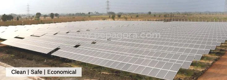
Solar Energy Maps provide critical data for planning and optimizing solar energy installations by delivering precise solar irradiance measurements. They help identify ideal locations, calculate potential energy generation, and evaluate project feasibility before significant investment. This approach reduces development risks and enhances project success rates for energy developers and financial stakeholders across various market segments.

These mapping solutions serve multiple sectors including utility-scale solar farms, commercial building installations, and agricultural solar applications. They support government energy planning, academic research institutions, and corporate sustainability programs by offering verified data for informed decision-making and regulatory compliance requirements. Real-world applications:
- Site selection analysis for utility-scale solar power plants in high potential regions
- Rooftop solar assessment for commercial and industrial building installations
- Agricultural solar project planning for irrigation systems and farm operations
- Government energy policy development and renewable energy target mapping
- Educational and research institutions studying climate patterns and renewable energy potential
Trade Details
| Available Stock | In stock |
| Sample Availability | No |
Payment Terms
| Payment Terms |
|
Company Profile
Benchmark Engineers and Consultants, Tamil Nadu
 Tamil Nadu, India
Electronics & Electrical•ManufacturerDistributor / WholesalerImporter / Exporter
Factory Details
Factory SizeBelow 1000 sqm
Annual Production Capacity0
Main Markets
Eastern Asia
South Asia
Southeast Asia
Solar Energy Map: Accurate Irradiance Data for Project Planning
Solar Energy Map delivers accurate solar irradiance data and site analysis for optimal solar project planning. Essential for developers, EPC contractors, and energy consultants seeking reliable solar resource assessments.
Min. Order Quantity: 1 units
Shipping
Shipping fee and delivery date to be negotiated. Contact supplier now for more details.
Benchmark Engineers and Consultants Tamil Nadu, India
Electronics & ElectricalManufacturer