undefined

Similar Products


Description
Professional Topographical Land Survey Services provide the critical foundation of accurate terrain data for successful project execution. We specialize in mapping the earth's surf...
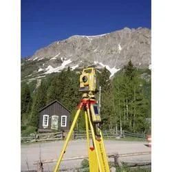
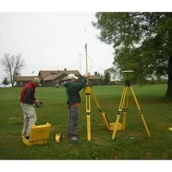
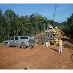
Professional Topographical Land Survey Services provide the critical foundation of accurate terrain data for successful project execution. We specialize in mapping the earth's surface—recording elevations, contours, and the location of natural and man-made features with precision. Utilizing advanced technologies like GPS, robotic total stations, and 3D laser scanning, our expert surveyors capture comprehensive data points to generate detailed topographic maps and digital terrain models. This information is indispensable for architects, engineers, and planners, offering a clear and reliable representation of the land as it exists, which is the first step in any responsible development.

These services are utilized across a spectrum of industries where understanding the lay of the land is paramount. In construction and civil engineering, surveys guide site layout, earthwork calculations, and foundation design. Urban planners and government agencies rely on them for development approvals, infrastructure projects, and floodplain analysis. The mining and agricultural sectors use topographic data for resource management and land development. Furthermore, environmental consultants apply this data for impact assessments, while telecommunications and utility companies depend on it for network expansion and maintenance planning, ensuring their infrastructure is optimally and safely placed.

The business value delivered is substantial, centered on risk mitigation, cost efficiency, and project confidence. Accurate topographic data prevents expensive redesigns, construction errors, and delays by revealing site conditions upfront. Our reliability stems from a rigorous process: experienced professionals, calibrated high-grade equipment, and multiple quality checks ensure data integrity. This commitment translates into surveys you can trust for crucial decisions, fostering smoother regulatory approvals, optimized material and labor costs, and ultimately, a more predictable and successful project outcome from conception to completion.

Key Features:
- High-precision data collection using GPS, total stations, and 3D scanning technology
- Detailed deliverables including contour maps, digital terrain models (DTMs), and CAD files
- Survey tailored to specific project scope, scale, and accuracy requirements
- Stringent quality control protocols verifying data accuracy and completeness
- Comprehensive reporting with clear visuals and actionable terrain insights

Benefits:
- Reduces project risk and prevents costly errors by revealing true site conditions
- Provides a reliable foundation for design, ensuring plans are feasible and buildable
- Enhances regulatory compliance and streamlines the approval process with accurate site documentation
- Optimizes construction planning and material estimates, improving budget control
- Delivers long-term value through trustworthy data usable for future site modifications or expansions
Specifications
| Additional Information | |
|---|---|
| Country of Origin | India |
| Customisable | No |
Application
Our professional topographical surveys create detailed maps of land contours, elevation, and existing features. This precise data is fundamental for initial site assessment, helping to visualize terrain challenges and opportunities before any design work begins. It forms the reliable base layer for all subsequent engineering and planning activities, ensuring projects are built on accurate information.

These surveys are critical for translating project concepts into buildable plans. The collected data directly informs grading designs, drainage solutions, and structural placement, mitigating risks associated with unforeseen site conditions. By identifying slopes, waterways, and other natural characteristics early, the surveys enable efficient design that works with the land, promoting safety and cost-effectiveness throughout the project lifecycle.
- Site planning and feasibility analysis for new construction developments
- Designing roadways, railways, and drainage systems with accurate slope data
- Creating base maps for municipal zoning, land use planning, and development permits
- Conducting environmental studies for erosion control and habitat management
- Mapping existing utilities and planning for new infrastructure networks
Trade Details
| Available Stock | In stock |
| Sample Availability | No |
Payment Terms
| Payment Terms |
|
Company Profile
A One Associates, Punjab
 Punjab, India
Factory Details
Factory SizeBelow 1000 sqm
Annual Production Capacity0
Professional Topographical Land Survey Services For Accurate Terrain Mapping
Professional Topographical Land Survey Services deliver precise terrain mapping for construction, infrastructure, and urban planning. We provide reliable, accurate land data using advanced technology to support your project's foundation.
Min. Order Quantity: 1 units
Shipping
Shipping fee and delivery date to be negotiated. Contact supplier now for more details.
A One Associates Punjab, India