undefined
Similar Products


Description
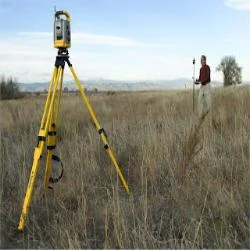
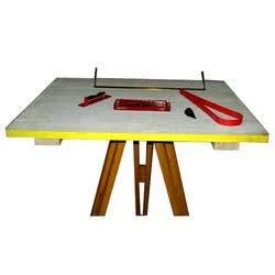
Our Land Surveying Plane Table Services deliver precise and efficient mapping for topography and land development. Utilizing skilled professionals and advanced surveying equipment,...
Our Land Surveying Plane Table Services deliver precise and efficient mapping for topography and land development. Utilizing skilled professionals and advanced surveying equipment, we provide accurate field plotting that captures terrain details directly on-site. This traditional yet effective method ensures reliable data collection, offering immediate visual representation essential for planning and execution. We focus on delivering tailored solutions that meet specific project requirements with high accuracy and within agreed timelines.

These services are integral to industries including construction, infrastructure development, and land management. Engineers, architects, and project managers depend on our plane table surveys for critical tasks such as site analysis, boundary identification, and detailed contour mapping. The method is particularly valuable for road projects, irrigation planning, and environmental evaluations, where accurate land information is fundamental to successful outcomes and regulatory compliance.

We emphasize reliability, precision, and client satisfaction in every engagement. Our approach combines expertise with modern techniques to ensure services that adhere to stringent quality standards. The value we provide includes minimized project delays, cost-effective surveying solutions, and enhanced decision-making support. Our differentiators are our commitment to customization, timely delivery, and consistent performance, building trust with serious buyers and project stakeholders.

Key Features:
- Direct field plotting for real-time topographical mapping
- Utilization of advanced surveying instruments and technology
- Tailored surveying approaches for specific project needs
- Accurate boundary demarcation and land measurement capabilities
- Detailed contour mapping and comprehensive terrain analysis

Benefits:
- Immediate on-site data visualization for faster project planning
- High accuracy in land measurements reducing rework and errors
- Customized solutions that align with unique project specifications
- Reliable boundary identification supporting legal and development needs
- Enhanced decision-making with precise topographical insights
Specifications
| Additional Information | |
|---|---|
| Country of Origin | India |
| Customisable | No |
Application
Plane table surveying provides precise field mapping essential for land development and construction planning. This method offers real-time plotting of topographical details, making it ideal for projects requiring immediate and accurate terrain visualization. It is widely adopted for its simplicity and reliability in capturing land features directly on-site.

Industries such as civil engineering, real estate, and infrastructure rely on these services for boundary demarcation, site analysis, and contour mapping. The technique supports road construction, irrigation design, and environmental assessments by delivering critical land data for informed decision-making and efficient project execution.
- Boundary demarcation and land parcel mapping for property development
- Topographical surveying for road and infrastructure construction projects
- Site planning and contour analysis for civil engineering works
- Land assessment for environmental and geological studies
- Terrain mapping for irrigation system and drainage design
Trade Details
| Available Stock | In stock |
| Sample Availability | No |
Payment Terms
| Payment Terms |
|
Company Profile
Dhyani Consultants Inc., New Delhi
 New Delhi, India
Electronics & Electrical•Distributor / WholesalerRetailerImporter / Exporter
Factory Details
Factory SizeBelow 1000 sqm
Annual Production Capacity0
Land Surveying Plane Table Services For Mapping And Topography
Accurate Land Surveying Plane Table Services for mapping and topography. Our expert team delivers reliable survey solutions for construction, infrastructure, and land development projects using advanced equipment.
Min. Order Quantity: 1 units
Shipping
Shipping fee and delivery date to be negotiated. Contact supplier now for more details.
Dhyani Consultants Inc. New Delhi, India
Electronics & ElectricalDistributor / Wholesaler