undefined
Similar Products


Description
Engineered for demanding professional use, our optical levels are precision instruments designed to deliver unwavering accuracy in surveying and construction alignment tasks. They ...
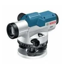
Engineered for demanding professional use, our optical levels are precision instruments designed to deliver unwavering accuracy in surveying and construction alignment tasks. They combine robust, field-ready construction with superior optical clarity to provide clear, reliable readings. A key advantage is their inherent stability; once set up, they maintain their calibration throughout the workday, eliminating the downtime and uncertainty of frequent readjustment. This reliability makes them the trusted choice for surveyors, engineers, and construction supervisors who cannot afford measurement errors, ensuring every project starts and finishes on a perfectly level plane.

These optical levels are deployed across a spectrum of critical industries. In civil engineering and construction, they are used to establish control points, verify foundation levels, and ensure structural components align precisely. Surveying professionals rely on them for boundary determination, topographic mapping, and volumetric calculations. The mining and quarrying sector utilizes them for pit development and stockpile measurements, while agricultural and environmental projects apply them for land forming, drainage design, and erosion control. Their versatility and straightforward operation make them suitable for both large-scale infrastructure projects and detailed site development work.

The business value of these instruments is rooted in their reliability and efficiency, which translate directly to cost savings and project confidence. Their durable build minimizes maintenance costs and extends service life, offering a strong return on investment. By providing consistent, accurate data without constant recalibration, they reduce labor time, prevent costly errors, and keep projects on schedule. This operational dependability builds trust with clients and stakeholders, as it ensures deliverables are based on precise, verifiable measurements. Choosing these optical levels means investing in a tool that enhances professional credibility and project outcomes through proven performance.

Key Features:
- High-precision optical system delivers sharp, distortion-free sighting for accurate readings.
- Rugged, durable construction built to withstand demanding site conditions and regular transport.
- Stable design that holds calibration, requiring minimal adjustment during extended field use.
- User-friendly setup with intuitive controls for fast operation and reduced training time.
- Trusted performance backed by a reputation for quality and reliability in professional markets.

Benefits:
- Achieve consistent, high-accuracy measurements that reduce the risk of project errors and rework.
- Increase on-site productivity with instruments that are quick to set up and reliable throughout the day.
- Lower long-term operational costs through durable construction and minimal maintenance needs.
- Enhance project credibility and client trust with data from a recognized, professional-grade tool.
- Gain a versatile solution suitable for a wide range of applications from construction to land surveying.
Specifications
| Additional Information | |
|---|---|
| Country of Origin | India |
| Customisable | No |
Application
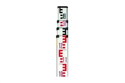
Professional optical levels establish exact horizontal reference planes and measure elevation differences with exceptional accuracy. These instruments are fundamental for projects where millimeter-level precision directly impacts structural integrity, regulatory compliance, and project timelines, providing reliable data from initial site assessment through to final verification.

These tools are indispensable across sectors that depend on exact elevation data. From laying building foundations and grading roads to mapping topography and setting irrigation slopes, optical levels offer a trusted, straightforward solution for field teams. Their consistent performance reduces measurement errors that can lead to costly rework or delays, making them a core asset for any serious project.
- Establishing level benchmarks and controlling elevation during building foundation and slab construction.
- Conducting topographic surveys and creating contour maps for land development and site planning.
- Setting precise grades and alignments for roadways, railways, and pipeline installations.
- Monitoring structural settlement and deformation in bridges, dams, and large infrastructure over time.
- Planning and implementing agricultural land grading, drainage systems, and irrigation layouts.
Trade Details
| Available Stock | In stock |
| Sample Availability | No |
Payment Terms
| Payment Terms |
|
Company Profile

Allys Hardware And Tools Private Limited, Tamil Nadu
 Tamil Nadu, India
Tools & Hardware•Trading CompanyDistributor / Wholesaler
Factory Details
Factory SizeBelow 1000 sqm
Annual Production Capacity0
Main Markets
Mid East
Eastern Asia
South Asia
Professional Optical Levels For Surveying And Construction Alignment
Professional optical levels for surveying and construction alignment deliver precise, reliable measurements without constant readjustment. Ideal for civil engineering, land development, and infrastructure projects requiring consistent accuracy.
Min. Order Quantity: 1 units
Shipping
Shipping fee and delivery date to be negotiated. Contact supplier now for more details.
Allys Hardware And Tools Private Limited Tamil Nadu, India
Tools & HardwareTrading Company