undefined
Similar Products


Description
Our professional GPS survey solutions represent the pinnacle of positioning technology for hydrographic mapping and precise navigation. These systems are engineered to deliver exce...
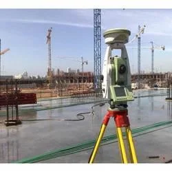
Our professional GPS survey solutions represent the pinnacle of positioning technology for hydrographic mapping and precise navigation. These systems are engineered to deliver exceptional centimeter-level accuracy, providing reliable real-time location data even in the most challenging marine environments. Designed specifically for surveyors, marine engineers, and environmental professionals, the technology ensures consistent performance while maintaining intuitive operation. The solutions integrate seamlessly with existing survey equipment and software platforms, offering comprehensive positioning capabilities that meet rigorous international standards for accuracy and operational reliability across global waters.

Multiple critical industries depend on our GPS survey technology for their essential positioning requirements. The maritime sector utilizes these systems extensively for port development, channel maintenance, and offshore construction projects requiring precise location data. Environmental agencies and research institutions employ them for coastal monitoring, habitat mapping, and climate change impact studies where accurate positioning is fundamental. Civil engineering firms rely on this technology for infrastructure projects including bridge construction, pipeline routing, and land reclamation initiatives. The energy sector, particularly offshore wind farm development, oil platform positioning, and submarine cable installation, demonstrates the versatile application of these systems across diverse professional domains requiring uncompromising accuracy.

Organizations select our GPS survey solutions for their proven reliability and substantial long-term value. The systems significantly reduce operational risks through highly accurate positioning data, minimizing costly errors in critical projects. Their durable construction ensures consistent performance in harsh marine environments, substantially reducing downtime and maintenance expenses. The technology's global coverage guarantees operational capability anywhere in the world, while its precision enhances project efficiency and data quality for superior decision-making. These factors combine to deliver exceptional return on investment through improved project timelines, reduced rework requirements, and enhanced operational confidence for professionals working in demanding marine environments.

Key Features:
- Centimeter-level positioning accuracy for precise hydrographic measurements
- Global coverage with reliable signal reception for worldwide operations
- Weather-resistant construction designed specifically for marine environments
- Real-time data transmission and immediate processing capabilities
- Robust integration with existing survey equipment and software platforms

Benefits:
- Reduces operational risks through highly accurate positioning data
- Minimizes project errors and costly rework in critical applications
- Ensures consistent performance in challenging marine environments
- Provides global operational capability with reliable worldwide coverage
- Enhances project efficiency and decision-making through precise data
Specifications
| Additional Information | |
|---|---|
| Country of Origin | India |
| Customisable | No |
Application
Our professional GPS survey systems provide precise positioning for demanding hydrographic mapping projects. Engineered for accuracy, these solutions deliver reliable centimeter-level data collection in challenging marine and coastal environments, supporting critical operations from offshore surveys to infrastructure development with consistent performance.

Industries including maritime navigation, offshore energy exploration, and civil engineering trust our GPS technology for essential positioning data. The systems maintain operational integrity across various weather conditions, ensuring uninterrupted support for time-sensitive projects and long-term environmental monitoring applications where precision is non-negotiable.
- Offshore oil and gas platform positioning and navigation support
- Port and harbor depth surveys for dredging operations
- Marine construction project positioning and structural monitoring
- Environmental monitoring including coastal erosion studies
- Underwater pipeline and cable route surveying and installation
Trade Details
| Available Stock | In stock |
| Sample Availability | No |
Payment Terms
| Payment Terms |
|
Company Profile
A One Associates, Punjab
 Punjab, India
Factory Details
Factory SizeBelow 1000 sqm
Annual Production Capacity0
Professional GPS Survey Solutions For Hydrographic Mapping And Positioning
Professional GPS survey solutions for hydrographic mapping and positioning deliver centimeter-level accuracy for marine, construction, and environmental industries requiring reliable real-time navigation and data collection worldwide.
Min. Order Quantity: 1 units
Shipping
Shipping fee and delivery date to be negotiated. Contact supplier now for more details.
A One Associates Punjab, India