undefined
Similar Products


Description
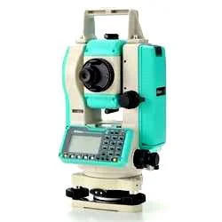
Our Professional GPS Survey Services are built on over a decade of specialized field expertise, providing businesses with trusted, high-precision geospatial solutions. We focus on ...
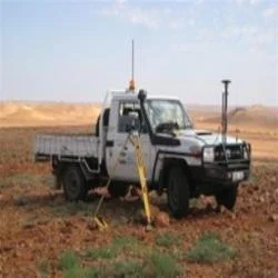
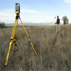
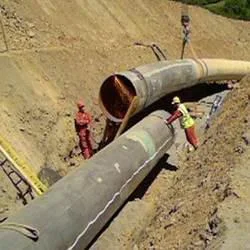
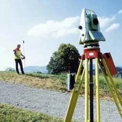
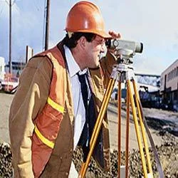
Our Professional GPS Survey Services are built on over a decade of specialized field expertise, providing businesses with trusted, high-precision geospatial solutions. We focus on delivering accurate positioning, detailed mapping, and reliable data collection using professional-grade equipment. Our approach combines advanced technology with practical experience to offer comprehensive surveying support that meets stringent industry standards for accuracy across diverse project scopes and challenging environmental conditions.

These services are indispensable across key sectors including construction, mining, civil engineering, and agriculture. Construction firms utilize our precise measurements for site layout, foundation work, and monitoring structural placements. Mining operations depend on our technology for accurate volume assessments, slope stability analysis, and exploration mapping. Civil engineers integrate our data for designing and verifying infrastructure like roads and pipelines, while agricultural managers use detailed maps for efficient land use and water management planning.

Clients choose our services for their proven reliability, technical precision, and adaptable project approach. Our long-term experience means we deliver more than just data; we provide end-to-end solutions including field support, expert data processing, and actionable reporting. This commitment ensures you receive dependable, survey-grade information that forms a solid foundation for critical project decisions, risk mitigation, and successful execution, making it a valuable investment for serious project teams.

Key Features:
- Centimeter-level accuracy using advanced GNSS/GPS positioning technology.
- Robust, weather-resistant surveying equipment suitable for demanding field conditions.
- Integration with industry-standard data processing and mapping software.
- Real-time kinematic (RTK) and post-processing capabilities for flexible workflows.
- Experienced survey teams providing end-to-end project support and quality assurance.

Benefits:
- Achieve high-precision measurements that reduce costly errors and project rework.
- Gain reliable, verifiable data for confident planning, reporting, and compliance.
- Enhance project efficiency with faster data collection and streamlined processing.
- Access expert technical support and consultation from seasoned surveying professionals.
- Obtain tailored survey deliverables that directly align with your specific project requirements.
Specifications
| Additional Information | |
|---|---|
| Country of Origin | India |
| Customisable | No |
Application
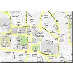
Our high-precision GPS survey services deliver centimeter-level accuracy essential for critical geospatial data collection. This technology supports mapping, boundary marking, and topographic surveys, enabling professionals to execute projects with confidence and precision, reducing errors and rework.

These services are fundamental for industries where exact measurements dictate project success. From initial site planning to final verification, our solutions provide the reliable data needed for infrastructure development, resource management, and land assessment, ensuring every decision is informed by accurate, real-world information.
- Construction site mapping, grading verification, and progress monitoring for large-scale projects.
- Land boundary and cadastral surveys for real estate development and legal property demarcation.
- Mining volume calculations, pit and dump mapping, and exploration site surveys.
- Infrastructure planning and as-built surveys for roads, railways, bridges, and utilities.
- Topographic mapping for agricultural land management, irrigation, and precision farming.
Trade Details
| Available Stock | In stock |
| Sample Availability | No |
Payment Terms
| Payment Terms |
|
Company Profile
Dhyani Consultants Inc., New Delhi
 New Delhi, India
Electronics & Electrical•Distributor / WholesalerRetailerImporter / Exporter
Factory Details
Factory SizeBelow 1000 sqm
Annual Production Capacity0
Professional GPS Survey Services High Precision Mapping Land Surveying
Professional GPS Survey Services deliver high-precision mapping and land surveying for construction, mining, and infrastructure projects. With over 10 years of expertise, we provide reliable, accurate data collection.
Min. Order Quantity: 1 units
Shipping
Shipping fee and delivery date to be negotiated. Contact supplier now for more details.
Dhyani Consultants Inc. New Delhi, India
Electronics & ElectricalDistributor / Wholesaler