undefined

Similar Products


Description
ESurvey Earthwork Volume Calculation Software is a specialized engineering tool designed to transform raw survey data into actionable project intelligence. It efficiently imports p...
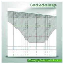
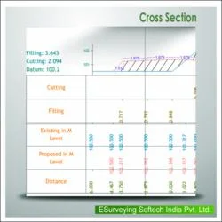
ESurvey Earthwork Volume Calculation Software is a specialized engineering tool designed to transform raw survey data into actionable project intelligence. It efficiently imports point data from CAD drawings, Excel spreadsheets, or CSV files, automating the complex process of calculating excavation and fill volumes. By generating accurate volume reports and detailed section drawings, it replaces error-prone manual methods, providing a reliable digital workflow for civil contractors, surveyors, and project engineers. The software's core function is to deliver precise quantity takeoffs, which are critical for project costing, bidding, and execution, ensuring that every cubic meter of material is accounted for from the planning stage through to completion.

This software finds extensive application across industries where earth movement is a primary activity. In civil construction and infrastructure development, it is indispensable for road, railway, and airport projects, determining exact cut and fill requirements. The mining industry utilizes it for pit design and overburden volume estimation, while land developers rely on it for site grading, contouring, and balancing earthwork. Environmental and agricultural projects also benefit from its terrain modeling capabilities for pond construction, drainage design, and land rehabilitation. Its adaptability to various data formats and calculation methods makes it a universal tool for any professional dealing with terrain modification and bulk earthworks.

The business value of ESurvey Earthwork software lies in its direct impact on project profitability and risk management. Its reliability is built on robust algorithms that ensure calculation accuracy, even for irregular sites and complex structures. This precision translates into reduced material waste, optimized haulage distances, and better cut-fill balance, leading to significant cost savings. The software differentiates itself through features like automatic optimum formation level calculation, which minimizes import and export of materials. By providing clear, auditable reports, it enhances communication between site teams, consultants, and clients, fostering trust and enabling more efficient project management and resource allocation.

Key Features:
- Import topographic data directly from CAD files, Excel spreadsheets, or CSV formats for seamless workflow integration.
- Generate comprehensive volume reports using fixed formation levels or by comparing two different surface models.
- Calculate earthwork quantities for complex structures and irregular sites using simplified line definitions to create 3D surfaces.
- Produce interim progress reports during project execution for continuous monitoring and quantity verification.
- Create detailed elevation grids and block level models without the need for intricate surface modeling processes.

Benefits:
- Achieve high accuracy in quantity takeoffs, reducing the risk of cost overruns and project delays due to estimation errors.
- Save considerable time by automating complex volume calculations that would otherwise require manual measurement and computation.
- Optimize cut-fill balance and material movement to lower transportation costs and minimize environmental impact from waste disposal.
- Enhance project planning and bidding with reliable, data-driven estimates that improve win rates and profitability.
- Improve site communication and documentation with clear, professional section drawings and standardized volume reports.
Specifications
| Additional Information | |
|---|---|
| Country of Origin | India |
| Customisable | No |
Application
ESurvey Earthwork software is essential for professionals managing terrain and material movement. It processes survey data from multiple sources to deliver precise volume calculations and detailed cross-sectional drawings. This eliminates guesswork and manual errors, providing a reliable digital foundation for project planning and earthwork management across various scales, from small site developments to major infrastructure works.

The tool's versatility makes it suitable for diverse project phases, from initial feasibility studies to final quantity verification. It supports both triangulation and block methods for quantity takeoff, adapting to different site conditions and engineering requirements. This flexibility ensures accurate material estimates for bidding, budgeting, and resource allocation, helping teams maintain project timelines and control costs effectively.
- Determining precise cut and fill volumes for highway and roadway construction projects.
- Calculating material quantities for railway embankments, cuttings, and track bed preparation.
- Managing earthwork for residential and commercial land development and site grading.
- Estimating excavation and fill volumes for large-scale water infrastructure like dams and canals.
- Supporting mining operations with accurate volume calculations for pits, stockpiles, and overburden.
Trade Details
| Available Stock | In stock |
| Sample Availability | No |
Payment Terms
| Payment Terms |
|
Company Profile

E Surveying Softech ( India ) Private Limited, Karnataka
 Karnataka, India
Factory Details
Factory SizeBelow 1000 sqm
Annual Production Capacity0
Main Markets
South Asia
Earthwork Volume Calculation Software For Civil Engineering Projects
ESurvey Earthwork Volume Calculation Software accurately computes excavation volumes and generates section drawings from CAD, Excel, or CSV data for civil engineering projects, ensuring precise quantity takeoffs and optimized cut-fill balance.
Min. Order Quantity: 1 units
Shipping
Shipping fee and delivery date to be negotiated. Contact supplier now for more details.
E Surveying Softech ( India ) Private Limited Karnataka, India