undefined

Similar Products


Description
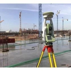
The Leica GS18 I represents a significant advancement in surveying technology, combining high-precision GNSS RTK capabilities with innovative visual positioning. This integrated sy...
The Leica GS18 I represents a significant advancement in surveying technology, combining high-precision GNSS RTK capabilities with innovative visual positioning. This integrated system allows surveyors to capture precise measurement points directly from images, transforming traditional surveying methods. The technology eliminates the need for direct physical access to measurement points, enabling data collection from safe, convenient positions. With tilt compensation functionality, measurements can be taken with poles held at any angle, removing the constraint of maintaining vertical alignment. The unit features robust construction with IP68 protection, ensuring reliable operation in challenging outdoor conditions across varying temperatures. Compatibility with Leica Captivate software provides an intuitive interface that enhances operational efficiency for surveying professionals.

The Leica GS18 I serves multiple industries requiring precise positioning and measurement capabilities. In construction and civil engineering, it facilitates accurate site layouts, foundation positioning, and structural alignment verification. Urban planning departments utilize its capabilities for topographic mapping, infrastructure development, and asset management. Environmental consultants employ the technology for land surveys, habitat mapping, and monitoring projects. The system proves particularly valuable for infrastructure development including transportation networks, utility installations, and public works projects. Its ability to capture measurements from images makes it indispensable for documenting existing conditions, monitoring construction progress, and verifying project compliance with design specifications.

Businesses investing in the Leica GS18 I gain substantial operational advantages through improved efficiency and reduced project timelines. The integration of visual positioning with GNSS technology minimizes measurement errors and enhances data consistency, leading to higher quality deliverables and increased client satisfaction. The reduction in fieldwork time and elimination of site revisits directly translate to cost savings and improved resource allocation. The system's reliability in diverse environmental conditions ensures consistent performance, reducing equipment downtime and maintenance requirements. These combined benefits make the GS18 I a valuable long-term investment for organizations seeking to enhance their surveying capabilities while optimizing operational costs and project outcomes.

Key Features:
- GNSS RTK technology combined with visual positioning for comprehensive measurement solutions
- Tilt compensation enabling measurements with poles at any angle without leveling requirements
- IP68 rated protection against dust and water ingress for durable outdoor performance
- Integration with Leica Captivate software for streamlined workflow management
- High-definition camera and advanced IMU system for precise image-based point capture

Benefits:
- Increases productivity by reducing fieldwork time and eliminating unnecessary site visits
- Delivers high accuracy with horizontal precision of 8 mm + 0.5 ppm
- Enhances safety by enabling measurements in inaccessible or hazardous locations
- Supports multiple applications across construction, mapping, and infrastructure sectors
- Provides reliable performance in challenging environmental conditions
Specifications
| productDetailPage.specification.attribute | productDetailPage.specification.value |
|---|---|
| Model | GS18 I |
| Technology | GNSS RTK with Visual Positioning |
| Accuracy | Up to 8 mm + 0.5 ppm (horizontal) |
| Additional Information | |
|---|---|
| SKU | AKR-LEI-GS18I |
| Country of Origin | 106 |
| Customisable | No |
Application
The Leica GS18 I revolutionizes surveying workflows by integrating GNSS RTK precision with visual positioning technology. This powerful combination enables professionals to capture accurate measurements directly from images, significantly reducing fieldwork time and eliminating unnecessary site revisits. Designed for demanding environments, it delivers reliable performance across various applications while maintaining exceptional accuracy standards.

This advanced rover excels in topographic surveys, construction layouts, and infrastructure development projects. It provides precise positioning capabilities even in challenging or inaccessible areas, supporting industries like civil engineering, urban planning, and environmental monitoring. By streamlining data capture processes and enhancing measurement reliability, it meets the rigorous demands of professionals seeking efficient and accurate surveying solutions.
- Topographic mapping and land surveying with rapid data collection across extensive areas
- Construction site layout and positioning for foundations, utilities, and structural elements
- As-built documentation and verification using captured images and derived measurement points
- GIS data collection and asset management for urban development and infrastructure projects
- Civil engineering projects including road construction, railway alignment, and pipeline installation
Trade Details
| Available Stock | In stock |
| Sample Availability | No |
Payment Terms
| Payment Terms |
|
Shipping & Logistics
| Shipping Internationally | No | |
| Methods | -- | |
| IncoTerms | -- | |
| Port of Dispatch | Indore, Mumbai | |
| Packaging Type | -- | |
| Units per Package | -- | |
| Barcode / HSN / GTIN / UPC | -- | |
| Dispatch Lead time | -- |
Company Profile
A. K. Rampurawala & Sons, Madhya Pradesh Madhya Pradesh, India
Construction•Trading CompanyDistributor / WholesalerImporter / Exporter
Factory Details
Factory SizeBelow 1000 sqm
Annual Production Capacity0
SKU: AKR-LEI-GS18I
High Precision Leica GS18 I GNSS RTK Rover With Visual Positioning
Leica GS18 I GNSS RTK rover with visual positioning delivers high-precision surveying for construction and mapping professionals, featuring 8 mm + 0.5 ppm accuracy and image-based point capture technology.
Min. Order Quantity: 1 Unit
Shipping
Shipping fee and delivery date to be negotiated. Contact supplier now for more details.
A. K. Rampurawala & Sons
 Madhya Pradesh, India
ConstructionTrading Company


