undefined
Similar Products


Description
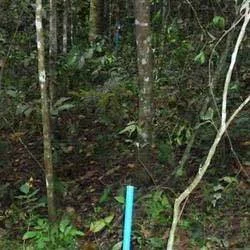
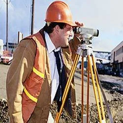
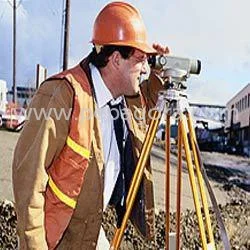
Our professional demarcation survey services deliver precise land boundary identification and marking using advanced surveying equipment and methodologies. We provide accurate, leg...
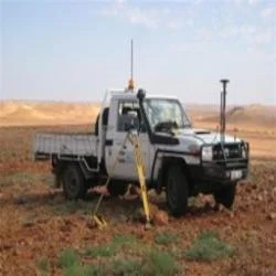
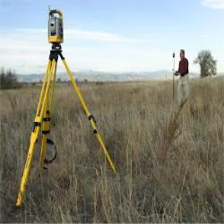
Our professional demarcation survey services deliver precise land boundary identification and marking using advanced surveying equipment and methodologies. We provide accurate, legally compliant surveys that establish clear property lines with thorough research of land records and comprehensive documentation. Our team ensures every survey meets strict quality standards while addressing specific site conditions and client requirements. The service includes physical boundary marking and authoritative documentation that serves as reliable reference for property ownership and development rights.

These demarcation surveys serve multiple industries including real estate development, construction, infrastructure projects, and government land management. Real estate developers utilize our services for project planning and compliance with local zoning regulations. Construction companies depend on our boundary markings for accurate site development and proper building placement. Government agencies employ our surveys for land records management, urban planning initiatives, and dispute resolution processes. The agricultural sector also benefits from proper land demarcation for farm planning and property transactions.

We deliver exceptional value through reliable, cost-effective surveying solutions that prevent expensive property disputes and legal complications. Our services ensure project timelines are maintained by providing accurate data from the outset, reducing delays caused by boundary uncertainties. The commitment to timeliness and accuracy makes us the preferred choice for businesses seeking dependable land surveying partners. We maintain compliance with all regulatory standards while delivering surveys that support informed decision-making and risk mitigation.

Key Features:
- Advanced surveying technology for precise boundary identification and marking
- Comprehensive land record research and historical document verification
- Professional survey approaches tailored to specific project requirements and site conditions
- Legal compliance with all local and national surveying standards and regulations
- Detailed documentation including maps, reports, and certified survey documents

Benefits:
- Prevents costly property disputes and legal complications through accurate boundary identification
- Ensures project timelines by providing reliable data from the outset
- Supports compliance with zoning regulations and development standards
- Facilitates transparent property transactions with authoritative documentation
- Reduces development risks by establishing clear, legally recognized property boundaries
Specifications
| Additional Information | |
|---|---|
| Country of Origin | India |
| Customisable | No |
Application
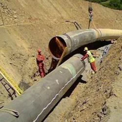
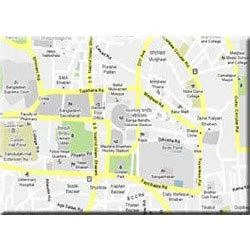
Professional demarcation surveys establish legally recognized property boundaries essential for development and ownership clarity. These services provide precise measurements that prevent disputes and ensure proper land utilization across various property types, from urban plots to rural parcels. The accurate boundary identification forms the foundation for all subsequent construction activities and property transactions.

These demarcation services are critical for multiple sectors including real estate development, infrastructure projects, and government land management. Industries rely on these surveys to comply with zoning regulations, facilitate transparent property dealings, and avoid legal complications. The services ensure smooth project execution from initial planning through completion by providing authoritative boundary references that guide development decisions.
- Property boundary verification for real estate transactions and legal documentation
- Land subdivision and partition surveys for development projects and inheritance settlements
- Construction layout marking for building foundations, roads, and infrastructure projects
- Dispute resolution and mediation support for conflicting property claims between neighbors
- Municipal planning and zoning compliance for commercial and residential development projects
Trade Details
| Available Stock | In stock |
| Sample Availability | No |
Payment Terms
| Payment Terms |
|
Company Profile
Dhyani Consultants Inc., New Delhi
 New Delhi, India
Electronics & Electrical•Distributor / WholesalerRetailerImporter / Exporter
Factory Details
Factory SizeBelow 1000 sqm
Annual Production Capacity0
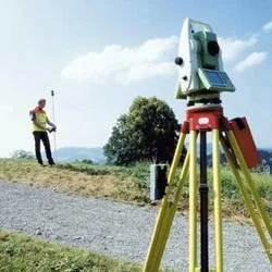
Professional Demarcation Survey Services For Accurate Land Boundary Identification
Professional demarcation survey services for accurate land boundary identification and marking. Trusted by real estate and construction industries for reliable, timely property demarcation solutions.
Min. Order Quantity: 1 units
Shipping
Shipping fee and delivery date to be negotiated. Contact supplier now for more details.
Dhyani Consultants Inc. New Delhi, India
Electronics & ElectricalDistributor / Wholesaler