undefined

Similar Products


Description
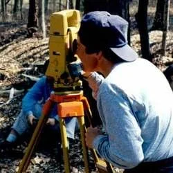
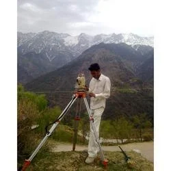
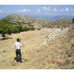
Our professional contour survey service delivers precise elevation mapping through carefully drawn contour lines that represent specific elevation points across any terrain. This a...
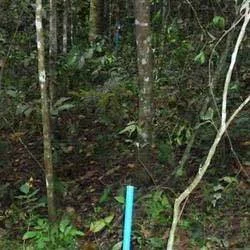
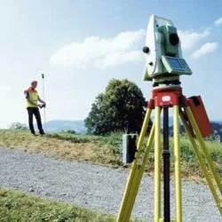
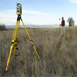
Our professional contour survey service delivers precise elevation mapping through carefully drawn contour lines that represent specific elevation points across any terrain. This advanced surveying technique creates detailed topographic maps that accurately depict the shape and features of the land surface. Each contour line connects points of equal elevation, providing a clear visual representation of slopes, valleys, ridges, and other terrain characteristics. This essential service enables engineers, architects, and project managers to make informed decisions based on reliable land data, ensuring project success from the planning stages through completion. The surveys are conducted using modern equipment and methodologies to guarantee accuracy and reliability for all types of terrain and project requirements.

Contour surveys serve critical functions across multiple industries including construction, mining, civil engineering, urban planning, and environmental management. In construction, these surveys guide site development, foundation design, and drainage planning. Mining operations utilize contour data for volume calculations, pit design, and resource management. Civil engineers rely on accurate elevation mapping for infrastructure projects such as roads, bridges, and pipelines. Urban planners use contour information for zoning decisions and municipal development, while environmental professionals apply this data for watershed analysis, flood prediction, and conservation planning. The versatility of contour surveys makes them indispensable across these sectors.

Businesses choose our contour survey services for their reliability, accuracy, and quality that ensure specific project requirements are met precisely. Our commitment to excellence delivers exceptional value through reduced project risks, optimized resource allocation, and compliance with regulatory standards. The reliability of our data prevents costly errors during construction and development phases, while our professional approach ensures each survey addresses unique project needs. This combination of technical excellence and client-focused service provides measurable business value through improved project outcomes, cost savings, and enhanced decision-making capabilities for all stakeholders involved in land development and infrastructure projects.

Key Features:
- Accurate elevation mapping with precise contour line representation
- Professional survey approaches tailored to specific project requirements
- Modern surveying equipment and advanced methodologies for reliable data
- Detailed topographic maps showing terrain characteristics and features
- Comprehensive coverage of various land types and project scales

Benefits:
- Enables informed decision-making for project planning and execution
- Reduces project risks and prevents costly construction errors
- Supports regulatory compliance and environmental responsibility
- Optimizes resource allocation and site development efficiency
- Provides reliable data for accurate volume calculations and earthwork
Specifications
| Additional Information | |
|---|---|
| Country of Origin | India |
| Customisable | No |
Application
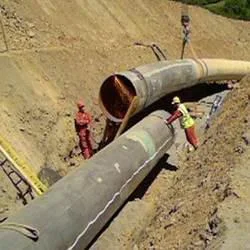
Contour surveys provide essential elevation data for terrain analysis and land development projects. These surveys create detailed topographic maps showing elevation changes through contour lines, enabling precise planning and engineering decisions across various industries. This service is critical for projects requiring accurate land measurement and slope analysis, ensuring proper drainage, foundation design, and earthwork calculations. The data helps professionals understand land characteristics before commencing construction or development work.

Industries including construction, mining, civil engineering, and urban planning rely on contour surveys for project feasibility studies and implementation. These surveys help identify potential challenges in land development, optimize site layouts, and ensure regulatory compliance. The accurate elevation data supports infrastructure projects, environmental assessments, and resource management, making contour surveys indispensable for responsible land development and sustainable project execution across multiple sectors.
- Construction site planning and development feasibility studies
- Mining operations for volume calculations and pit design
- Civil engineering projects including road and railway alignment
- Urban planning and municipal infrastructure development
- Environmental management and watershed analysis
Trade Details
| Available Stock | In stock |
| Sample Availability | No |
Payment Terms
| Payment Terms |
|
Company Profile
Dhyani Consultants Inc., New Delhi
 New Delhi, India
Electronics & Electrical•Distributor / WholesalerRetailerImporter / Exporter
Factory Details
Factory SizeBelow 1000 sqm
Annual Production Capacity0
Professional Contour Survey Services For Accurate Elevation Mapping
Professional contour survey services deliver precise elevation mapping and terrain analysis for construction, mining, and infrastructure planning projects, ensuring reliable data for critical development decisions.
Min. Order Quantity: 1 units
Shipping
Shipping fee and delivery date to be negotiated. Contact supplier now for more details.
Dhyani Consultants Inc. New Delhi, India
Electronics & ElectricalDistributor / Wholesaler