undefined
Similar Products


Description
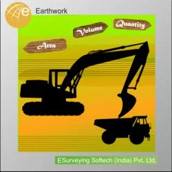
ESurvey Sections is a professional civil engineering software designed for precise cross-section creation and CAD integration. This specialized tool enables engineers and surveyors...
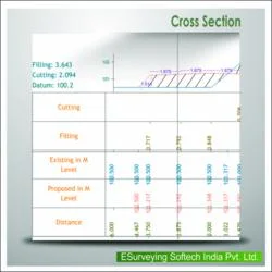
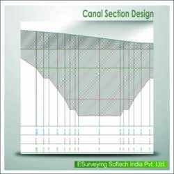
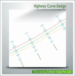
ESurvey Sections is a professional civil engineering software designed for precise cross-section creation and CAD integration. This specialized tool enables engineers and surveyors to generate industry-standard drawings and instant calculation reports for various linear infrastructure projects including roads, railways, irrigation canals, pipelines, and sewer networks. The software supports comprehensive data import from Excel, CAD platforms, and field survey books, allowing users to create detailed cross-sections and longitudinal sections efficiently. With dynamic modification capabilities and extensive customization settings, it ensures accuracy and adaptability to specific project requirements, making it an indispensable solution for professional engineering workflows and technical documentation.

This software finds extensive application across civil engineering, construction, and public infrastructure sectors. Irrigation departments utilize it for designing efficient canal systems with precise water flow calculations. Transportation authorities employ it for planning road and rail networks with accurate alignment profiles. Municipal corporations depend on it for developing sewer and water pipeline projects with proper gradient and capacity planning. Consulting engineering firms and survey companies also rely on ESurvey Sections for precise earthwork calculations, profile designs, and compliance with technical standards, significantly enhancing productivity and reducing project timelines across these diverse industries and applications.

ESurvey Sections delivers substantial business value by improving project reliability, reducing manual calculation errors, and streamlining deliverable preparation. Its integration capabilities with CAD systems and Excel ensure suitability for diverse project requirements and existing workflows. Features like advanced area-volume calculations and dynamic section modifications enhance decision-making accuracy and operational efficiency throughout project lifecycles. The software's ability to export data and print sections on custom templates supports seamless collaboration and comprehensive documentation, establishing it as a trusted solution for professionals seeking quality performance and technical precision in infrastructure design tools and engineering software applications.

Key Features:
- Import survey data from Excel, CAD platforms, and field books for cross-section generation
- Design and edit complex profiles for irrigation systems, roads, and infrastructure projects
- Calculate area and volume using trapezoidal or nett area methods with extrapolation
- Modify sections dynamically to meet specific area requirements and project specifications
- Export section data to Excel and CAD formats with custom drawing template printing

Benefits:
- Streamlines cross-section creation and reduces manual drafting time significantly
- Enhances calculation accuracy for earthwork volumes and project specifications
- Improves collaboration through seamless CAD and Excel integration capabilities
- Increases productivity with dynamic modification tools and automated reporting
- Ensures compliance with industry standards and technical requirements
Specifications
| Additional Information | |
|---|---|
| Country of Origin | India |
| Customisable | No |
Application
ESurvey Sections serves civil engineers and surveyors working on linear infrastructure development. It creates accurate cross-sections and longitudinal profiles essential for designing irrigation canals, road networks, railway alignments, and pipeline systems. The software integrates seamlessly with Excel and CAD platforms, providing versatile data import, modification, and export capabilities for complex engineering projects.

This solution benefits consulting firms, government infrastructure departments, and construction companies requiring detailed earthwork calculations and standardized drawings. It simplifies complex profile designs, area-volume computations, and dynamic section adjustments while ensuring projects meet technical specifications. The software saves significant time and reduces manual errors through automated calculations and professional reporting features.
- Designing precise irrigation canal networks with accurate cross-sectional profiles and slope calculations
- Creating detailed longitudinal sections for road and railway alignment planning projects
- Modeling sewer and pipeline systems with comprehensive volume and area analysis reports
- Generating earthwork calculations for construction projects using trapezoidal or nett area methods
- Exporting section data to CAD and Excel for collaboration in infrastructure development
Trade Details
| Available Stock | In stock |
| Sample Availability | No |
Payment Terms
| Payment Terms |
|
Company Profile

E Surveying Softech ( India ) Private Limited, Karnataka
 Karnataka, India
Factory Details
Factory SizeBelow 1000 sqm
Annual Production Capacity0
Main Markets
South Asia
Civil Engineering Software For Cross Section Design And CAD Integration
ESurvey Sections civil engineering software enables precise cross-section design, CAD integration, and area calculations for irrigation, pipeline, and infrastructure projects with reliable performance.
Min. Order Quantity: 1 units
Shipping
Shipping fee and delivery date to be negotiated. Contact supplier now for more details.
E Surveying Softech ( India ) Private Limited Karnataka, India