undefined
Apparel & Fashion
Loading subcategories...
View More
Description
Our professional topographical survey services deliver comprehensive land mapping and terrain analysis using state-of-the-art surveying technology. We provide precise measurements ...
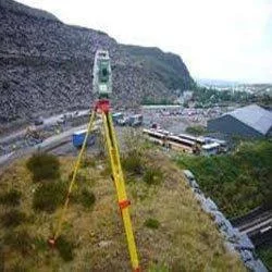
Our professional topographical survey services deliver comprehensive land mapping and terrain analysis using state-of-the-art surveying technology. We provide precise measurements of natural and man-made features, including detailed elevation data, contour lines, drainage patterns, and existing structures. Our experienced surveyors utilize advanced GPS systems, total stations, and drone technology to capture accurate spatial data that serves as the essential foundation for construction and development projects. This thorough mapping enables clients to make informed decisions during critical planning stages, ensuring projects are built on reliable, precise terrain information.

These survey services are vital across multiple sectors including construction, civil engineering, urban planning, and infrastructure development. Construction companies depend on our surveys for accurate site analysis and optimal building placement, while municipal authorities utilize them for urban development planning and regulatory compliance. Engineering firms require our precise topographical data for road design, drainage systems, and utility infrastructure planning. Environmental organizations use our surveys for habitat mapping and conservation projects, and resource management companies rely on our terrain data for operational planning and safety compliance.

We deliver significant business value through reliable, accurate surveys that minimize project risks and prevent costly errors. Our commitment to quality ensures clients receive trustworthy data for critical decision-making processes. Our experienced professionals possess deep understanding of local conditions and regulations in Maharashtra, providing surveys that offer the certainty needed for successful project execution. This service helps clients avoid unexpected obstacles, ensures compliance with planning authorities, and maximizes development potential while maintaining high standards of accuracy and reliability.

Key Features:
- Advanced GPS and drone technology for precise data collection
- Detailed contour mapping and elevation profiling
- Comprehensive feature mapping including natural and man-made elements
- Accurate spatial data collection using total stations
- Experienced professional surveyors with local Maharashtra expertise

Benefits:
- Reduces project risks and prevents costly construction errors
- Provides reliable data for informed decision-making
- Ensures compliance with local regulations and standards
- Helps avoid unexpected obstacles during project execution
- Optimizes land utilization and development potential
Specifications
| Additional Information | |
|---|---|
| Country of Origin | India |
| Customisable | No |
Application
Topographical surveys provide essential terrain data that forms the foundation for successful infrastructure development. Our detailed mapping of elevation, contours, and natural features enables engineers and planners to design projects that align with actual site conditions, reducing construction risks and ensuring optimal land utilization across Maharashtra's diverse landscape.

These surveys capture comprehensive site information including existing structures, vegetation, and drainage patterns. This critical data supports regulatory compliance, helps identify potential obstacles early, and ensures projects meet safety standards while maximizing development potential for various infrastructure needs throughout the region.
- Urban development and municipal infrastructure projects
- Road, highway, and transportation network planning
- Residential and commercial construction site development
- Environmental assessment and conservation initiatives
- Mining operations and natural resource management
Trade Details
| Available Stock | In stock |
| Sample Availability | No |
Payment Terms
| Payment Terms |
|
Company Profile
Eagle Engineers, Pune, Maharashtra
 Maharashtra, India
Services & Support
Factory Details
Factory SizeBelow 1000 sqm
Annual Production Capacity0
Main Markets
North America
South America
Eastern Europe
Southeast Asia
Central America
Topographical Survey Services For Infrastructure Planning In Maharashtra
Professional topographical survey services for infrastructure planning in Maharashtra deliver precise land data, contours, and elevation details using advanced technology for construction and development projects.
Min. Order Quantity: 1 units
Shipping
Shipping fee and delivery date to be negotiated. Contact supplier now for more details.
Eagle Engineers, Pune Maharashtra, India
Services & Support