undefined
Apparel & Fashion
Loading subcategories...
View More

Description
Our professional route survey services deliver comprehensive earth surface mapping along specific paths using advanced surveying methodologies and precision instruments. We special...
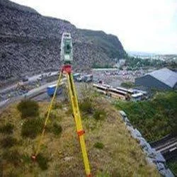
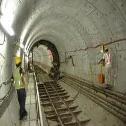
Our professional route survey services deliver comprehensive earth surface mapping along specific paths using advanced surveying methodologies and precision instruments. We specialize in collecting accurate topographical, geological, and soil data through techniques including plane-table surveying, tachymetry, and aerial photo topographic surveying. Our team provides reliable route survey data that forms the essential foundation for successful infrastructure projects, ensuring proper center line marking, cross-section leveling, and precise route alignment. We maintain the highest standards of accuracy and reliability in all surveying operations, delivering critical information that supports informed decision-making and thorough project planning from conception through execution.

Route survey services serve multiple industries including transportation infrastructure development, energy sector expansion, and telecommunications network growth. Construction companies depend on our expertise for road and highway projects, while energy providers utilize our services for pipeline route planning and power transmission line routing. Government agencies and municipal authorities engage our route survey capabilities for urban development initiatives, rural connectivity programs, and public infrastructure upgrades. The mining industry also benefits from our geological and topographical surveying for access road development and resource transportation planning, ensuring safe and efficient operations.

The business value of our route survey services includes significant risk reduction, optimized resource allocation, and ensured regulatory compliance. The reliability of our data enables clients to make confident investment decisions and avoid costly errors during project execution. We differentiate through unique quality standards, exceptional reliability, and comprehensive service options tailored to specific project requirements. Our commitment to using the latest surveying technologies and methodologies ensures clients receive the most accurate and current information available, supporting project success and long-term infrastructure durability.

Key Features:
- Advanced plane-table and tachymetry surveying techniques
- Comprehensive topographical and geological data collection
- Precise center line marking and route alignment services
- Cross-section leveling and slope assessment capabilities
- Aerial photo topographic surveying for large-scale projects

Benefits:
- Reduced project risks through accurate terrain assessment
- Optimized resource allocation with precise route planning
- Enhanced regulatory compliance with comprehensive data
- Improved project efficiency through informed decision-making
- Long-term infrastructure durability with reliable surveying data
Specifications
| Additional Information | |
|---|---|
| Country of Origin | India |
| Customisable | No |
Application
Our route survey services provide essential earth surface mapping for infrastructure projects requiring precise path planning. We deliver accurate topographical, geological, and soil data using advanced surveying methodologies including plane-table, tachymetry, and aerial photo topographic techniques. This comprehensive data collection enables engineers and planners to make informed decisions about construction feasibility and optimal route alignment across diverse geographical conditions.

These professional surveying services support critical infrastructure development across transportation, energy, and utility sectors. Our expertise in center line marking, cross-section leveling, and route alignment provides vital information about terrain characteristics and material quality assessment. This enables optimal path selection for various projects while ensuring comprehensive data collection meets specific project requirements and geographical challenges.
- Road and highway construction planning with precise alignment optimization
- Pipeline route surveying for oil, gas, and water transmission systems
- Railway track alignment and terrain assessment for new rail networks
- Power transmission line routing through challenging geographical terrain
- Telecommunications infrastructure development and underground cable routing
Trade Details
| Available Stock | In stock |
| Sample Availability | No |
Payment Terms
| Payment Terms |
|
Company Profile
Eagle Engineers, Pune, Maharashtra
 Maharashtra, India
Services & Support
Factory Details
Factory SizeBelow 1000 sqm
Annual Production Capacity0
Main Markets
North America
South America
Eastern Europe
Southeast Asia
Central America
Infrastructure Development Route Survey Services For Accurate Mapping
Professional Infrastructure Development Route Survey Services deliver accurate earth surface mapping using advanced methodologies and precision instruments for reliable topographical, geological, and soil data collection along designated paths.
Min. Order Quantity: 1 units
Shipping
Shipping fee and delivery date to be negotiated. Contact supplier now for more details.
Eagle Engineers, Pune Maharashtra, India
Services & Support