"ESurvey Sections" is a complete Section Creation and Management Solution designed to help Engineers, Surveyors and Designers to create industry standard drawings and to generate instant calculation reports related to Road / Railway lines / Irrigation / Pipeline design / Sewer Network Project.
Key Features and Benefits of E Survey Sections:
Importing Data:
Import data from Excel for Generating Cross Section and Longitudinal Section Drawings
Import Alignment data from CAD
Import data from Field Book
Extensive Section Settings:
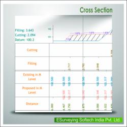
Change properties like Colour / Height / etc. for all the elements of a section
Print Graph and Projection Lines
Print Header / Footer with Scales
View Sections in different Horizontal / Vertical Scale
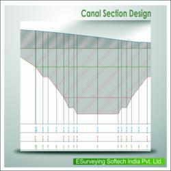
Profiles:
Design Complicated profiles and shapes for various requirement like irrigation, roads etc
Dimension Profiles
Inserts CAD blocks
Area/Volume Calculations:
Generate Area / Volume Report in Excel and CAD using either of two methods Trapezoidal or Nett Area
For area calculation use advanced techniques such as extend / extrapolate or join ends
Modify Sections Dynamically to arrive at required area
Printing Sections:
Plot sections on your own drawing templates and export to CAD package
Alternatively print the Survey Sections from within the package
Exporting Section:
Export Section data to Excel
Export Section data back to CAD along an alignmen
Benefits
Save considerable time while generating multiple Survey Sections and respective area and volume report from excel / CAD / Field book data
Extensive Section setting allows you to create highly presentable ESurvey Sections
Sections related to Road way, Railway, Tank and Pipeline can be done by learning only one package
Use E Section irrespective of your CAD Package as E Section works with AutoCAD® /BricsCAD / ZW CAD / Ares / ProgeCAD/GstarCAD/
Cad cam consultant providing cad cam designing services which includes e survey cad services, earth work services, generating topological maps, calculating earthwork quantities and e topo drawing services.
More details:View company website
Its Free
Verify Now


